
Asia Impact Craters - Projective geometry and earth expansion. The plates are an expansion of the large proto planets that have hit earth and been absorbed. https://www.youtube.com/watch?v=3HDb9Ijynfo
.jpg)
Siberian Traps Impact. This one broke the crust/earths mantle, a Crustus Confractus >>>>

So here we have crater fractals. That is where the the crater rim retains so much energy it has to radiate it to resolve. You can see it over runs the Alaska Aleutian Island chain impact which occurred earlier.
.jpg)

This area is still resolving the earth curst break. Does that mean it is newer than the Siberian Traps? Not necessarily, it could just be more difficult.
Earth stretching from absorming large protoplanets.

Afghanistan - Large earth impact with fractal energy and crossing banding wave (a step harmonic). The iron on top is from the impact center which was vaporized and fell back to earth. Impacts this large can blast fragments back out into space to fall as meteorites later.
.jpg)

Tectonic push over previous large craters.
.jpg)
Siberian Impact Extinction Event

Coning wave forms
Coning wave forms
Coning wave forms
Bakauheni-Lampung. Indonesia

Saudi Arabia impact made strata. Nano iron and cobalt. Shock granular particle construction matrix. Take a look below.


Ok, this is a transition phenomena as you are aware. It is from Impact which broke the earth's crust. Pillow Basalt is a harmonic signature from the resonate shock. This is the less formed state of low harmonic signature as is the surrounding mountains which are crater walls. As the earth is self healing the plate is repairing as a resolving of stress. Elbrus Anda Hajar mountains of Oman
.jpg)
In Yemen they have a more formed columnar basalt. So which was closer to the center of impact? The theory is that shock must organize with distance to make geometric forms. So Oman would be closer.
.jpg)
Oman, earth crust break crater wall type. Not shock organized. The parallel faults shown below are the nominal surface crater wall expression.
.jpg)
.jpg)
Alas I have it backwards, the harmonic becomes disorganized as it gets in the edge jumble over in Oman and is centered in the ocean.
.jpg)
Yemen's Socotra Island is more near the center of the impact. See the force projections straight up?
.jpg)
These powerful earth crust breaking impacts turn the crust into a liquid via shock and rebound the center which is Socotra Island.
.jpg)

Notice how the background mountains (crater wall) in Yemen outline the chevron shape (shatter cone) but are in filled with column type up progression. You are looking at the columnar basalt morphology sequence. This impact was a bullet type, punching through quickly, dense and fast. Also this impact was probably after the carbon period and caused a compression of the oil toward Saudi Arabia in the sub surface strata. That is why it is under so much pressure. Same would be true of the impact at Chicxulub being late it would push the subsurface oil into a compressed state like we saw with the BP well blowout with the Deepwater Horizon. Great pressure.


Tube Coning - A high shock vertical effect of impact making the earth liquid. It fast cooled like a picture.
In the depths of the Kamceatka peninsula lies an amazing, unique valley - Kutkhiny Baty -
Kutkhiny Baty is a strange valley made of bright and whitish pumice stone.
The Kamchatka Peninsula is a 1,250 km long peninsula in the Russian Far East with an area of approximately 270,000 km². it lies between the Pacific Ocean to the east and the Sea of Okhotsk
to the west

I can't take credit for the discovery of the Aral Sea Impact Crater, that honor belongs to Terry Westerman. I do see another here just below where the Kazakhstan valley of the sphere is located. I was looking for it to be smaller. Here is his map below.

I would have made the center a little to the west. Obviously the Himalayan Impact came later. You can see his website at: http://geoledgers.com/Impacts.html

Siberian crater impact sphere. Large earth impacts make large impact spheres. This one is a coated type with a layer, a two step process. It is degrading, it appears to contain copper.

Shock made metamorphic - The inclusion is part of the impact explosion blast. The matrix is a 50 GPa harmonic with the high shock version of coning, the triangle wave. You can see that by the cleavage patterns. Low shock coning is crude and has striations. Specimen photo by: Abrar Dawar

Wadi Kub – UAE’s Geological Marvel. This is minerals from the impacting bolide.

Magic Rabbit, less than a thousand remain. But look at the rocks. This is part of the crater strata from the big Mongolian Basin Impact. NW China.

The Siberian Craton Impact late Devonian Extinction Event - The earth is still resolving this impact crust stress along its south side as it hit from the north. The north side was fully absorbed into crust.
.jpg)
Crust stress with plate movements and the later east side impacts of the Siberian Craton Impact.
.jpg)
And here we have the magnetic pole shift. This is due to the older established Impact pole from the Canadian smaller impact which caused the Cambrian Extinction being heat absorbed into the earth as a blog and moving to the larger later mass.

.jpg)
The Afghan lapis mines a crater edge vein deposit from the Himalayan Impact.
.jpg)

The look of old overlapping craters like you might see on the moon.

Richard Nass · January 9, 2018 ·
I am alway so intrigued by Gobi desert Agates . They are so unique and interesting . Like no other in design and colors.
Big high energy impact very large earth crater. Complex impact spheres with tube fractals, pseudo morphic crystal fast forms, high diversity of nano minerals and shock circles.

Impact mega clast. See the striation patterns. The top is in more of a melt. This grain structure shows a fast made energy from right to left. A nodule from the impacted area blasted out who knows how far. Sept 26, 2022
Archaeology and Ancient Civilizations
·
A camel petroglyph at the Bir Hima complex which covers the time period of 2500–1000 BC. Najran province in southwest Saudi Arabia


Institute of Alternative History and Archaeology
·
These megalithic marvels don't get nearly enough coverage as the pyramids or stonehenge etc but these incredible feats of engineering are found in Krasnodar, Russia and definitely aren't created using primitive chisels as proposed.

Very high energy effects. Smooth bore holes are a tunneling circle wave effect. This site has no surface chiseling marks, it is an impact phenomena. Boring square wave cut with boring circle wave. Notice the top arrow pointing to the fractal with the branching away from the cut features. That is the energy bleeding off. The second lower angle points to the rejection patterns on the surface. They are also in a high energy "shock" state, a signature of impact.

A crater. So why isn't it round? Craters do not have to be round. The earth has more than a million craters and just like you see on other planets they intersect and overlap. Also large crater structures will not be bowl like smooth inside the crater. Impact is a complex multi staged event.
.jpg)
Big Crater Complex with overlap
.jpg)
Crust crinkling does not mean a floating crust that rams into other crust plates. These are records of impacts, many which overlap. The crust is still resolving these stresses. They make a bowl shape not a ramming shape. The impacts are all different so these types of stresses will be different. The order of impact is also making a complex stress.

𝗧𝗛𝗘 𝗚𝗜𝗔𝗡𝗧 ❜❜𝗦𝗧𝗢𝗡𝗘 𝗘𝗚𝗚𝗦❜❜ 𝗢𝗙 𝗞𝗔𝗭𝗔𝗞𝗛𝗦𝗧𝗔𝗡
In Kazakhstan it is called Torysh, or Valley Of Balls (literally Valley of the Spheres): Impact spheres from a large crater. April 9, 2023

Impact signature, narrow coning to fractal. Yes, it is very old. Weathering as a physical mechanism will never make this. It would require a constant force weather pattern which fickle weather patterns cannot hold. An impact explosion can make this. Narrow coning is the highest power type, so we know this was a powerful impact. The breakdown to tree fractal from coning is a physical form step progression. You can see that the top of the coning repeats the cone then shifts to tree fractal. This is a progressive energy form step. You can see the crater topographically.
Turtle Rock, also known as Melkhii Khad, is a famous landmark located in Mongolia. It is situated in the Gorkhi-Terelj National Park, which is about 55 kilometers northeast of Ulaanbaatar, the capital city of Mongolia. Aug. 14, 2023.


Tube splash drops. The tapering is pointing towards the center of the impact. Sept. 6, 2023.
Ancient knowledge
Hin Sam Wan, also known as Three Whale Rock, is a stunning rock formation that is approximately 75 million years old and rises dramatically from the mountains in Thailand. Its name originates from its resemblance, when viewed from the right angle, to a family of whales, making it a unique and remarkable sight.


Al Huqf Geopark, Oman. Impact spheres. Sept. 12, 2023.

Impact spheres, Elat Israel. Oct. 6, 2023.
Giora Michaeli
About 40 km north of Eilat Israel. How you explain this rocks? There are some hundreds of its.

Resonate banding and wet form slippage. This is associated with crater walls or distance. The bands have some sine wave structure. The bands are vertical striated. Vertical striation between bands is the harmonic imprinting the between banding noise. Oct. 6, 2023.
Fault zone outcrop is in an openpit lignite mine in the late Miocene–Pliocene Ptolemais Basin, West Macedonia Greece. Photo Copyright © John Walsh. Fault Analysis Group, University College Dublin.


Notice how the earthquakes have the same structure as a crater. Oct. 8, 2023.
https://www.forbes.com/.../earthquakes-in-afghanistan.../

Impact spheres (round impactite spheroids). Oct. 12, 2023.
Giora Michaeli · ·
About 40 km north of Eilat Israel. How you explane this rocks? There are some hundreds of its.

Map ID: MID000003 – Download Image
Map: Major Fault Lines in the Near East
Region: Aegean, Anatolia, Caucasus, Levant, Mesopotamia, Arabian Peninsula, Egypt
Description: Topographical map of the Eastern Mediterranean and the Near East with major fault lines noted with yellow dashed lines
Category: Maps
Type: Topographic Maps
Period: Modern
Date: 2005
Credit: Stephen Batiuk, September 2005

Impact ash layer topped with the swirling deposit from impact with directionality from right to left. Note the iron which is from the impacting meteor/bolide itself. Oct. 24, 2023.
Josef Charrach · ·
Soft sediment deformation of lacustrine sediments due to a strong earthquake. Lisan Fm, Pliestocene. Nahal Prazim, west of Mt. Sdom, Israel

Crater shift. Formation event with burnt ash and iron content. Oct. 26, 2023.
Geomorphological Features
A normal fault near Tbilisi in Georgia. Rock layers to the right of the fault plane have moved downward relative to the rock layers on the left. Credit: Luka Adikashvili (distributed via imaggeo.egu.eu).

Impact strata, melt folding, fractal intrusions, impact tectonic. You can see the crater on the attached gravity map. Nov. 4, 2023.
Geology Wonders
·
Gorgeous Ptygmatic fold - KRS Railway cutting KRS, MANDYA.
Photo Copyright @vinay_chidanand

Is this the same crater as "The Earth's Innie Navel"?

The answer is yes, unless proven otherwise. Even though we do not have a perfect overlay the powerful impact implied on the India map is too big to not go into the ocean as a crater area. This impact is a full blown type 1 Crusta Confratus, Earth penetrating accretion. Nov. 4, 2023.

Impact cavitation, Gornaya Shoria in Russia a crater. Nov. 18, 2023.


Before Barringer, earth impact craters were called crypto volcanic. This is the same misunderstanding. The actual crater is visible topographically. Can an earth impact create volcanoes? You bet it can. Is called a Crusta Confractus. Dec. 11, 2023.
The study is published open access in Proceedings of the National Academy of Sciences.
Viet Nam.
The location of the Bolaven Volcanic Field in Southeast Asia, and the site of the suspected impact crater and tektites of the right age within it.
Image credit: Sieh et al, Proceedings of the National Academy of Sciences 2023 (CC BY-NC-ND 4.0)

Column basalt is the up splash bubbles forming tubes from a big earth impact. Dec. 15, 2023.
Volcanically derived, angled hexagonal columns, Hong Kong Global Geopark, Hong Kong. (credit:Fcracer; https://fcracer.com/unesco-global-geopark-hong-kong/)


Impact landing split. Dec. 19, 2023.
The Al Naslaa rock is a landform 50 km south of the Tayma oasis in Saudi Arabia. It is split down the middle into two parts, both balanced on small pedestals.[1] The overall shape of the rock may be due to wind erosion and chemical weathering that could have been possible due to the moist conditions in the protected underside of the rock.[2] It is split in two by what could be a joint.
The rock is about 6 metres high and 9 metres wide, and is covered on its south-east face with numerous petroglyphs.[3]


Sparta, TN Impact Crater, Bald Knob Mt. Impact landing split. This is the same phenomenon as shown above in Saudi Arabia. Dec. 19, 2023.

Here is a more complete look at the old and newer craters of Saudia Arabia. Dec. 19, 2023.

Earth impact writ large. Boxwork Septarian - The layers are the larger shock wave. The large Septarian is a resonate high shock that separates minerals by attenuation hence the mineral change in the forms. It has secondary communication cracks between these Boxwork Septarian forms indicating that the initial energy was too large to be imprinted without secondary bridge level two iteration. Attached is the large earth impacts in overlay as like other planets these craters are serial usually with sequence going from large to smaller. Dec. 20, 2023.
Danjie Mendoza Tapalla II · ·
Hi all! I just wanted to introduce myself and share a photo I took this afternoon in our town, Quezon, Philippines


Boudin type inclusion with direction. As a hydrodynamic flow the tapered end would point the flow direction. Impact ash turned to slate by the impact high pressure. Color - Impact makes nano particles besides the ash. Nano minerals like iron or manganese make these pastel colors. False strata lines - False strata is the imprinting of shock waves into the surrounding material. Notice they disappear on top. This is due to the impact progression with the high shock imprinting now gone and just a build up of more ash/slate. Tilt - Impact tectonics makes a tilt surround the crater which can be in all angles as this is an explosion dynamic. Crater size - Very large crater which is shown in the topographic, faults, and macro geology. Dec. 26, 2023.
Lalhming Hlua
Can anyone please explain how this was formed (highlighted in red)? Photo taken from Mimbung Village, Mizoram, India. It is from sedimentary formation exposed by road construction.


Exposing "plate tectonics fundamental fault." Let's start with its parent Alfred Lothar Wegener (/ˈveɪɡənər/;[1] German: [ˈʔalfʁeːt ˈveːɡənɐ];[2][3] 1 November 1880 – November 1930) was a German climatologist, geologist, geophysicist, meteorologist, and polar researcher. This guy is imposing meteorology upon solid land mass and earth construction. His theory implies vapor cloud movements and collision. At the time of his thesis the idea of the earth having been formed as an accretion body was not yet accepted. For example, the head of the USGS said the moon has impact craters but not the earth. Sadly, many geologist still espouse this. Impact Tectonics is the logic of an accretion body. It explains all exhibited earth plate activity. Circles, arcs and swirls - While vapors and liquids can make these figures solids do not. Forming solids into arcs requires a forming die. You can do this experiment at home. Take any crinkle type material and push it around on a ball. You will never get the patterns of earth. Convection and subduction - Accretion bodies will split a seam like the Atlantic riff from receiving large accretions expanding the overall sphere. Large accretions type 2 impacts do not explode on the surface type 3. The average angle of impact is 45 degrees and they reflect a large push up on one side of crater forming what is thought to be a plate collision mountain. These very often still retain an arc which is impossible to form with plate collision. Volcanos and earthquakes - many earth impacts break the earth's crust called a Crusta Confractus. This allows for volcanos. Even a type 3 exploding impact will damage the earth's crust making rubble at various depths which is resolved by earthquakes. Science - We use the thesis progression system in science. Wegener's thesis was better than the previous (antithesis). We retained the erosion thesis and added plate activity. This would be the new synthesis. Impact better explains the observed dynamics so it replaces Wegener's thesis to form a new synthesis, Impact Tectonics. Dec. 26, 2023.

Figure 1.
Deccan Traps - Impact volcanism is the theory that first a big cosmic impact occurs and that breaks the Earth's crust causing volcanism. Figure 1. is weighted circles of the land visible exposure of the Deccan Traps. Figure 2. is the remnant topo crates of India. Figure 3. is the ocean of storms with gravity mapping. (Ocean of Storms on the Moon
The full moon as seen from the Earth, with the Ocean of Storms (Procellarum) border structures superimposed in red. (Image credit: Kopernik Observatory/NASA/Colorado School of Mines/MIT/JPL/Goddard Space Flight Center))
All impacts are unique. Overlapping impacts will make a complex stress pattern in the Earth's crust causing a non-circular crustal break as if opening an old wound. Also the magma could have splashed from the Himalaya Impact. Feb. 4, 2024.

Figure 2. Did the big splash from the Himalaya Impact cause the Deccan Traps? Feb. 4, 2024.

Figure 3. Squaring - the famous Barringer Crater in AZ (Meteor Crater, AZ) is not round. Impacts are unique and the object impacting can be any shape causing an irregular crater. Like the Deccan Traps multi crater wound stress complicates the crater form. This area of the Moon has adjacent impact craters that oppose the outward forming crater crust cracks. Feb. 2, 2024.

Shock made coning sequence. Or is this a crossing grid pattern made by overlapping shock wave imprints? Jan. 5, 2024.
Geology
김대관 · ·
Hello. The picture below is a prehistoric petroglyph. It's a rock made of Honfels. There are the checkered straight lines that connects vertically and horizontally between the patterns. Would you please explain to me how it's formed.
The second picture is looking down at the rock on which the petroglyphs are written. The third picture shows this rock from the side.
Let me ask for your understanding that the map below has been deleted to prevent damage to prehistoric sites.
Petroglyph Location: Gyeongsan-si, Gyeongsangbuk-do, Korea

yes there is also inscribed graffiti. Jan. 5, 2024.

Splatterform Impactite with surface fizzing a couple of plasma holes in matrix. The big three craters of UAE shown below. Feb. 8, 2024.


February 23, 2021
Subsurface structure investigation of the United Arab Emirates using gravity data
-
Hakim Saibi , Diab Bakri Hag , Mohammed Saeed Mohammed Alamri and Hamdan Abdo Ali
From the journal Open Geosciences

The Biggest Crater Cluster on Earth. This giant type 2 Subduction Crater Himalayan Impact is just peppered with other big Earth Impacts. March 15, 2024.
كىتاپخۇمارلار ئۇۋىسى Uyghur Bookshelf ·
Tarim basin where approx. 4000-year-old white Europoid mummies were found.

Opps, I missed one a big slider coming in from the SE, a real subduction digger. That is the source of those beautiful shock agates of the region. March 15, 2024.

Impact obsidian from the Black Sea Crater in the country of Georgia. May 11, 2024.
Geological Wonders
Cynthia Miller · ·
Obsidian field in the beautiful country of Georgia.

Impact made geoplastic lateral flow. Dead Sea Israel. May 14, 2024.
SORS - Ricerche Speciali

Impact bricking with the blast iron in an overlapping grid in sandstone. The slab was deposited at this place in the cratering process. May 18, 2024.
Gemstone Gurus ·
·
ThE SAiL ROCk
Krasnodar Krai, Russia
"Also known as Parus Rock, is a natural sandstone monolith of late Cretaceous age located on the shore of the Black Sea. It resembles the outline of a ship's sail, hence its name. The thickness of the rock is just over 1 meter, the height is more than 25 meters, and the length is over 20 meters. The rock is more than three-quarters out in the sea perpendicular to the shore. At the height of about 2.5 meters there is a hole in Sail

The plain of jars, Cambodia. Impact spheres. Were they hollow impact spheres? Yes, you can see that in the front right sphere. Modified by the indigenous people. July 9, 2024.
modernexplores.com uk.

The Cambodia Crater. July 9, 2024.

Impact Sphere/Nodule Variants falsely identified as fossils. Sept. 4, 2024.
Extraordinary stromatolites from Oman. (Credit: Roman Garba)

Large crater up splash constructions in north Ural Mountains. Most pictures do not allow for a close look at these formations. As you can see in the magnification the top has an up splash liquid melt coning effect. Sept. 23, 2024.
Manpupuner rock formations, Russia* is a mysterious site in the northern Ural mountains, made out of seven rock towers bursting out of the flat plateau, also known as the “7 strong men“. These monoliths are around 30 to 42 meters high. According to a local legend, the stone pillars were once an entourage of Samoyeds giants walking through the mountains to Siberia in order to destroy the Vogulsky people. However, upon seeing the holy Vogulsky mountains, the shaman of the giants dropped his drum and the entire team froze into the stone pillars.


A tale of two craters. It is the West Siberia crater that made these forms. Sept. 23, 2024. Figure is from.
Geological map of Russia showing simplified distribution the major fold belts onshore Russia prospective for oil and gas: 1-Tuapse, 2-Kuban, 3-East-Caucsus, 4-Karpinsiy swell, 5-Urals, 6-Timan, 7-Taymyr, 8-Enisey, 9 -Kuznetskiy, 10-Patom, 11-Verkhoyansk, 12-Indigiro-Zyryan, 13 -West Kamchatka, 14 -Sakhalin. Numbered lines show locations of sections shown in the paper
Source publication
PE-176609-MS Fold Belts: Shall We Expect a Shift in Petroleum Exploration Priorities?
Conference Paper
Full-text available
-
Oct 2015
Oil and gas exploration in Russia passed through 3 cycles of rapid reserve base build-up. The first one is related to the exploration in the foothills of the Caucasus. The second successful exploration campaign occurred in the Volga-Urals. The last one took place in the West Siberia.

Impact made landscape. In the foreground you can see plasma cavitation holes. Just left and back from there you can see type 1 impact bricking grid patterning. And of course in the background you have narrow coning with striations. This type of vertical striation is an iterative form made by overlapping narrow coning waves. Oct. 5, 2024.
The Stone Forest or Shilin is a remarkable collection of limestone formations measuring about 500 km2 located in Shilin Yi Autonomous County, Yunnan province, China.
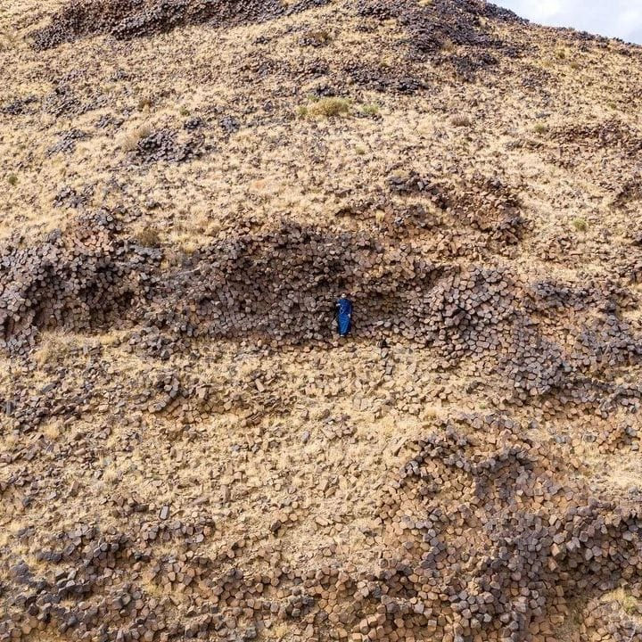
This honeycomb/columnar basalt effect is from a large earth impact that sent up these bubbles in a continuous tube with equal side compression forming the impact geometrics. It has blossomed on the surface and fell over as it was still in a plastic state. Oct. 18, 2024.
𝐀𝐬𝐞𝐞𝐫 𝐑𝐞𝐠𝐢𝐨𝐧, 𝐒𝐚𝐮𝐝𝐢 𝐀𝐫𝐚𝐛𝐢𝐚


Aseer Region
Large type 1 impact that penetrated the earth's crust. Multi ring modified effect with a sloping depression. Oct. 18, 2024.

Fiber crystal development. With impact glass you can see this transition development. Yes it is bubbling also as it was very very hot. About 5,000 degrees F I would imagine. Has provenance is not slag glass. Nov. 26, 2024.
Ivan Doležal - Dolmat
CONTRIBUTION TO THE PROBLEM OF "INTERESTING" OBSIDIANS SURFACE!
THE RARE "BUBBLE" OBSIDIAN
Weight: 214g
Dimensions: 80 x 70 x 20 mm
Location: Lake Sevan, Armenia
Old age: approximately 100,000 years
Price: 2,100 CZK
This rare bubble obsidian was created by the harsh cooling of very permeated lava respectively. magmaty. During its movement, magma releases volcanic gases that rise up to the surface of the melt. Due to rapid cooling, the gas bubbles preserved in obsidian make it possible to study the composition of volcanic gases. Their presence also results in a silver glow on the internal surface of the bubbles. Under these conditions, this type of obsidian was born. Its surface forms inner walls of burst bubbles and at the same time contains a large number of closed bubbles up to 1 cm in size! In addition, with the decreasing content of iron oxide, its transparency grows, and this is the case of this piece. Obsidian is a completely transparent, light brown color. In many countries, including the USA, collecting obsidian in certain locations is prohibited by law.
Lake Sevan is geologically young, about only one million years. The base consists of swelling, saliva, porphyrite and lime. The SV coast is formed by a large surface chalk opiolithic structure, while the western and southern edges of the lake are formed by linear volcanic ridges, which are known for their quadruple volcanic activity.

GFZ World Gravity Map. You can see the earth crust penetrating impacts of the Armenian region. These are the negative low gravity signatures. Nov. 26, 2024.


Relief map or Armenia. Lake Sevan would appear to be a crater, however the big earth crust breaking impacts Crusta Confractus dominate the geology including column basalt up splash tubes. Armenia has peak type up splash geology as well.


Tarim basin crater an oval slider from the NE. Dec. 6, 2024.

Coning up thrust at the Tarim Basin. Dec. 6, 2024.

Shock made oolite developments in c, d, and f. Dec. 6, 2024.
Silicon isotopic constraints on the genesis of cherts in the Ordovician sedimentary succession in Tarim Basin, Western China
Article
-
Jan 2021
The Tarim Craton is the largest petroliferous basin in China, and thick chert have been found in the Ordovician carbonate reservoir during drilling. Owing to the tight chert, the storage performance may decrease and lead to drilling failure. In this study, silicon, oxygen, and strontium isotope compositions of chert were tested to constrain the sou...

Popigai Impact Crater Siberia. This is what earth craters look like. Raft/Plate tectonics as a theory fails as it is unable to produce round or arc earth crustal features. Jan. 3, 2025. Picture Popigai: Russia’s Crater of Diamonds – Estimated To Contain “Trillions of Carats”

But look what the earth features really look like, is covered in circles and arcs. Plate tectonics does not apply to other planets and earth either. It is a failed theory. Jan. 3, 2025.

Angled impact makes one sided arcs in this case in series. Arc faults are present in the Howell, TN Impact Structure as it was very oblique. Jan. 3, 2025.

Arc faults in NW quad. Jan. 3, 2025.
General Geology of the Popigai Crater - Impact Craters

Impact Breccia Popagai Crater with tiny diamonds. Jan. 3, 2025.
https://geology.com/articles/popigai-crater-diamonds/


Gondwana Research
Volume 91, March 2021, Pages 121-128
GR Letter
First finding of impact cratering in the Korean Peninsula
Author links open overlay panelJaesoo Lim, Sei-Sun Hong, Min Han, Sangheon Yi, Sung Won Kim
What is important about this article?
1. Small crater and has shatter cones. This is a common systemic failure of impact research to look for shatter cones. You are most likely to find them with small craters and looking for them excludes larger craters.
2. Banding is present and is not a slow sedimentary process it happened in minutes. It is called false strata.
3. Honeycomb strata. This is commonly thought to be a weathering process but is really high heat evaporation or plasma bubble cavitation both impact made processes.
4. Inter mountain craters are more difficult to spot topographically.