

Ash, iron and sulfur and turbulence in the Chattanooga Shale in the western crater area Giles County, TN.
Energy Stratigraphy - What does a regional strata show as energy imprints: impacts, tectonic stress, flood or flowing water deposits, still water gravity based deposits, life based deposits.
Lee's law of impacts and orogeny. First set the stage then put the characters on it.
The contours will be the environment. The contours are created by the tectonic forces and impacts. you must first understand that to understand the life or lack thereof present.
1C-Zircon and Chattanooga Shale - The concept that strata are laid down in a related uniform layering and impact geology are incompatible. The disturbance of an impact event as large as the Frankewing, TN 40 mile crater into the sea would remove layers i.e. the unconformity below and push layers mixing radially and with back waves. Here is a description by Wilson in the 1990 State of Tennessee Division of Geology publication Pre-Chattanooga Stratigraphy in Central Tennessee Page 119 " A quarry in the Bigby facies about one mile east of Franklin, Williamson County, on Liberty Pike, contains two small plano-convex lenses of a fissile, thinly laminated, black shale. The condition of deposition of this shale in a sea characterized by major agitation is hard to visualize.
Energy stratigraphy is the best approach to understanding geology. The Frankewing, TN Impact occurring at the time of the Chattanooga Shale period and made a radioactive signature still detectable today as radon gas the rarest detectable earth crust element. Besides the likely higher radioactive content the mega bolide contained, the shock chaos explosion enriched the heavy elements like lead into heavier ones like uranium which is decaying into radon. You can read about shock chaos explosions at https://www.hillbillyu.com/kinetic-impact-explosion-crater
Impact glass is found on the Western Highland Rim of Middle TN through the Chattanooga Shale and Brassfield Chert. The Ft. Payne Chert is mixed with iron and even nickel iron along this ridge. The Chattanooga Shale is distinctive through Middle TN and is used to reference your strata. It has been hotly debated in the past regarding it's age. It varies in depth and extends a large area around the east continent. As you can read on Wiki https://en.wikipedia.org/wiki/Chattanooga_Shale it overlies an Ordovician unconformity and underlies the Murry Shale and Ft. Payne Chert. The dark organic bog like content of the Chattanooga Shale indicates land nearby with a rich vegetation. It is a type of alluvial deposit. I contend that the shale and Ft. Payne chert were both present in formation during the Howell, TN impact event. The center of the impact is really at Frankewing, TN. The Chattanooga Shale is macerated unlike some strata which layed down unbroken fossils. The greatly disturbed bottom may have affected the Conodont https://en.wikipedia.org/wiki/Conodont
This layer is also slightly radio active and combustible. You can read a lengthy study about this layer at: https://pubs.usgs.gov/pp/0357/report.pdf?fbclid=IwAR09U69HZwyEMX_M8beOUysaSk14pOUEdSfcYqr51T-rJLvxbtfm_SnC_W8 Bentonite, phosphate and an un conformity are also present in this strata. Phosphate could be a material from the bolide itself or reaction related sequence in this disturbed dynamic. The un conformity itself is likely to be the wipe produced by the blast which was large. On page 26 of the above study is a chart showing the Hardin Sandstone pushed up as it grows more distant from the Frankewing, TN blast in a southwest direction. The sandstone has phosphate and pyrite and is more course at it's base. The specimen below found SE Giles County, TN contains a fine iron sandstone ridge running through it along with the jumble of quartz concretions and iron. This specimen is Ft. Payne chert with blast metals sand turned into quartz. Also radioactive see: https://www.hillbillyu.com/radioactive-effect
Large mid Ordovician unconformity impact forming Middle, TN Basin. Subsequent large organic bog shores. But it is black or dark for several reasons all impact related. Fe3O4 black iron oxide, carbon, ash.

About 35 million years ago, an asteroid hit the ocean off the East Coast of North America. Its impact formed a 25-mile diameter crater that now lies buried beneath the Chesapeake Bay, an estuary in Virginia and Maryland. From this impact, the nearby area experienced fires, earthquakes, falling molten glass droplets, an air blast and a devastating tsunami.
While the resulting "Chesapeake Bay impact crater" is now completely buried, it was discovered in the early 1990s by scientific drilling. It now ranks as the largest known impact crater in the U.S., and the 15th largest on Earth. (both the Middle, TN "Basin Buster" and Howell/Petersburg are larger!)
When the asteroid hit, it also produced an impact ejecta layer, which includes tektites (natural glass formed from debris during meteorite impacts) and shocked zircon crystals which were thrown out of the impact area. Scientists refer to this layer as the "North American tektite strewn field," which covers a region of roughly 4 million square miles, about 10 times the size of Texas. Some ejecta landed on land while the rest immediately cooled on contact with seawater and then sank to the ocean floor.
A team of researchers, including Arizona State University School of Earth and Space Exploration scientist and lead author Marc Biren, along with co-authors Jo-Anne Wartho, Matthijs Van Soest and Kip Hodges, has obtained drilling samples from the Ocean Drilling Project site 1073 and dated them with the "uranium-thorium-helium technique" for the first time.
Their research was recently published in the international journal Meteoritics & Planetary Science.
"Determining accurate and precise ages of impact events is vital in our understanding of the Earth's history," Biren said. "In recent years, for example, the scientific community has realized the importance of impact events on Earth's geological and biological history, including the 65 million years old dinosaur mass extinction event that is linked to the large Chicxulub impact crater."
The team studied zircon crystals in particular because they preserve evidence of shock metamorphism, which is caused by shock pressures and high temperatures associated with impact events. The dated crystals were tiny, about the thickness of a human hair.
"Key to our investigation were zircon -- or to be more precise: zirconium silicate -- crystals that we found in the oceanic sediments of a borehole, which is located almost 400 kilometers (250 miles) northeast of the impact site, in the Atlantic Ocean," says co-author Wartho, who began the study when she was a lab manager at the Mass Spectrometry Lab at ASU.
For this study, Biren worked with co-authors Wartho (now working at GEOMAR Helmholtz Centre for Ocean Research Kiel), Van Soest and Hodges to prepare samples for analysis and to date zircon crystals with the uranium-thorium-helium dating method. Biren then identified and processed shocked zircon fragments for imaging and chemical analysis with an electron microprobe.
"This research adds a tool for investigators dating terrestrial impact structures," Biren said. "Our results demonstrate the uranium-thorium-helium dating method's viability for use in similar cases, where shocked materials were ejected away from the crater and then allowed to cool quickly, especially in cases where the sample size is small."
Story Source:
Materials provided by Arizona State University. Note: Content may be edited for style and length.
Journal Reference:
-
M. B. Biren, J.-A. Wartho, M. C. VAN Soest, K. V. Hodges, H. Cathey, B. P. Glass, C. Koeberl, J. W. Horton, W. Hale. (U-Th)/He zircon dating of Chesapeake Bay distal impact ejecta from ODP site 1073. Meteoritics & Planetary Science, 2019; 54 (8): 1840 DOI: 10.1111/maps.13316

Boulder below is Chattanooga Shale along a hill at Lake Logan , TN showing the impact disturbance in the still forming formation and it selling again.

Close up of boulder shown above showing iron from meteor as mixed string like inclusions.

Another specimen with thin iron sandstone layer from SE Giles County, TN.

In the above cited article it states on P. 45 "The "varved" bed at the base of the middle unit of the Gassaway member consists chiefly of quartz, together with mica, clay, spores, and other organic matter. The concentration of the organic matter in layers gives the rock its banded or varved appearance. Zircon grains, though small, are fairly abundant. Most of the quartz grains are between 0.008 and 0.07 mm in diameter, much the greater part of them being in the size range of silt (less than 0.062 mm).
In Hardin and Wayne Counties, Tenn., and in nearby parts of Perry County, Tenn., and Tishomingo County, Miss., the Chattanooga shale is chiefly a calcareous and phosphatic quartz sandstone having thin layers of black shale. Morse (1930) recognized the equivalence of these beds with the Chattanooga shale but proposed the term Whetstone Branch formation for them (p. 18). A thin section of typical calcareous sandstone from Morse's type locality along Whetstone Branch (loc. 235) shows poorly sorted and poorly rounded quartz sand having abundant fragments of phosphatic fossils of many types. Pyrite is irregularly distributed, chiefly as interstitial fillings. Feldspar, showing albite and microcline twinning, makes up 1 to 2 percent of the thin section." Micro grains of Zircon were recently cited as produced by the Barringer Crater Event
Transformations to granular zircon revealed: Meteor Crater, Arizona
Date:
July 27, 2016
Source:
Geological Society of America
Summary:
Having been reported in lunar samples returned by Apollo astronauts, meteorites, impact glass, and at a number of meteorite craters on Earth, granular zircon is the most unusual and enigmatic type of zircon known. The mechanisms and transformations that form this distinctive granular zircon have, until now, remained speculative because it has not been produced in shock experiments.
Albite is associated with Volcanic or Impact Events. There is no evidence of a volcanic event in this area. This volcanic glass was found in the chert of the Western Highland Rim which is pointed out in the chert section of the Tech Notes.
On P. 26 of the above cited article you can see a graph of the Hardin Sandstone pile up over Wayne County, TN. This push is consistent with the impact removing the sea floor for a great distance.
The Frankewing, TN Impact Event pushed sediment into an existing crater at Flynn Creek. On P. 55 of the above cited article it referenced the Flynn Creek Meteor Crater as receiving a great amount of the Dowelltown Shale. "COMPACTION The Flynn Creek cryptoexplosive area affords an unusual opportunity to determine the amount of compaction the shale has undergone since the end of Chattanooga time. As already stated (p. 10), the shale in this basin is as much as 200 feet thick, and the overlying Maury formation and Fort Payne chert sag about 100 feet over the thickest part (fig. 3). As also pointed out, it is highly probable that this subsiding area was continuously filled with the accumulating mud. The shale within this small basin differs in no apparent respect from that of the surrounding area except in being as much as 10 times as thick. Virtually all the extra thickness is in the Dowelltown member."
In the chert section of my Tech Notes I state that I think the Howell Meteor Impact Event was in the Mississippian Chert period. This marker of a great push is significant for dating the Frankewing, TN Event. I am not convinced however that strata are as uniform as is generally understood to be and a disturbance this great shows a concentric effect blasting down to previous strata and redistributing and changing the forming ones. P. 64 links these strata with Glauconite The sedimentary provenance is from supracrustal felsic elements on continental margin environment with acid magmatic arc (foreland basin). (from Wiki) "X-ray study in the survey laboratory indicates that the bright blue-green shaly "chips" that are common at the top of the Maury probably contain glauconite. These chips are commonly an inch or two long and are restricted to about the two top inches of the formation." P. 74 shows a peek in uranium during this transition strata.
Impact geology affords a forensic evaluation that speaks to issues not otherwise understood in the sedimentary process. The contour of impact strata is changed and also defined like a sounding sonar. It is assumed that the strata were uniform when a Continental Sea is likely not giving way to existing landforms rises in the surroundings. Lifeforms would also vary in this geography.
The Howell/Petersburg impact disturbs the organic shore, then it returns. Strata can represent a terrain condition more than a time period.

Point of impact Howell/Petersburg >>>
chart by Bob Beavers Engineering Inc. from Wilson (1990)
Boulder below from same location with mixing and small iron inclusion.


The Chattanooga Shale mapped in the blast area. Notice the three concentric faults, but also notice the outline of the Chattanooga Shale. It almost defines the crater but for the wash back that would happen in an impact into a sea.

The Barrens - This is an area so named because it was unproductive and swampy. It also coincides with the Chattonooga Shale edge and shocked rock is found NE of Tullahoma up highway 41a as to show a shock edge extending beyond The Barrens. The Barrens is likely just outside the crater wall receiving a large sludge push. The picture below is from Penspring Hollow in Giles County. It shows the turbulent pile up of small shells in the Chattanooga Shale along the crater wall area.

The back side of the SW crater wall as seen near the border with Alabama is shown below. It is angular cross bedding with shell lag deposits.

Besides the limestone Chattanooga shale you have slate in the Chattanooga sequence. Some of that slate is an oil bearing variety. The specimen below is from Lake Logan, TN in SE Giles County the SW part of the crater and contains no oil but nano metals as a deposit in it. This slate would be a compaction form imparted with the elemental blast into a forming slurry as the sequence was as yet unformed.

Shown below is an exposed strata near Coldwater, TN which would be near crater floor. The shock pressure has made the strata liquid with a directional flow coming laterally from right to left. Some parts are denser hence the Angelfish pattern in upper left. The circles are roll up swirls. Are lots of then with iron inclusions but this is the only one I have even seen with a limestone roll up.

Angel fish >>>>>>>>>>>>

Ash, almost cement strata at Prospect, TN as Chattanooga Shale. Specimen below found a little closer to blast center is cement. Cement is just ash and calcium and heat which are all present in an impact into a shallow sea.


Here is the angular sandstone metal crossbedding in Alabama again. This section is 25 miles NE of Wheeler Dam on the uppermost TVA impounded flood plane. It has nano cobalt and iron. A frozen moment of solidification post impact.

Very Very Rare. This is a shock made clast paper thin. Made as a shock liquid with instant fossils most young turned to fossils in the shock pressure nano bit transfer, a late Devonian mix, a shock made Chattanooga Shale. The Chattanooga Shale comprises many altered configurations and defines the Howell Impact Strata limits. The Chattanooga Shale limit is north Middle, TN. Attempts to construct it farther north are misguided and are connecting a different event strata. Lower section of Johnson Top SW Franklin County, TN, from Howell Impact thrown 50 miles or 2x crater diameter. Chart below.


Looking back into crater floor from Johnson Top. This former section of the Highland Rim was pushed southeast by the Howell Impact. The Highland Rim was more circular and is the crater wall of the Middle TN Basin Buster a large Devonian Impact.

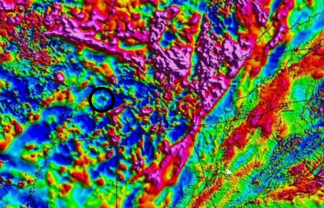
Not only does lazy geology fail to find craters as shown above with this higher detail Radon Map it connects strata that does not connect. The Chattanooga Shale ends in upper Middle TN as it encounters the North Middle TN Basin Buster Crater Wall (Highland Rim). The similar strata found north is just that "similar strata."

Here we have a Chattanooga Shale Bolder thrown atop Bear Hollow Mt. WMA in Frankline County, TN below Winchester. It has the radioactive signature of the Howell Impact along with the radioactive iron splatter.

On the Origin of a Phosphate Enriched Interval in the Chattanooga Shale (Upper Devonian) of Tennessee – A combined sedimentologic, petrographic, and geochemical study
-
November 2015
DOI:10.1016/j.sedgeo.2015.09.005
Authors:
Request full-text
To read the full-text of this research, you can request a copy directly from the authors.
The Devonian Chattanooga Shale contains an uppermost black shale interval with dispersed phosphate nodules. This interval extends from Tennessee to correlative strata in Kentucky, Indiana, and Ohio and represents a significant period of marine phosphate fixation during the Late Devonian of North America. It overlies black shales that lack phosphate nodules but otherwise look very similar in outcrop. The purpose of this study is to examine what sets these two shales apart and what this difference tells us about the sedimentary history of the uppermost Chattanooga Shale.
Now this sad article is typical of the befuddlement of geology. First of all Chattanooga Shale is a type of instant strata made by impact. Like the Mississippi Valley Type (MVT) of iron deposits it was first named in the US South and has been not understood but largely applied to mis explain. The Chattanooga Shales are different because they were made from different impacts. The MVT's are also different and were made by impacts. Not sedimentary which is one tool fits all geology concept never mind you can see 40,000 craters on Mars which is also believed to have sedimentary geology but the major effects are impact particularly considering even the core planet is an accretion impact body.
EARTH, ATMOSPHERIC, AND PLANETARY SCIENCES
OPEN ACCESS
The internal structure and geodynamics of Mars inferred from a 4.2-Gyr zircon record
Maria M. Costa, Ninna K. Jensen, Laura C. Bouvier, +10, and Martin Bizzarro https://orcid.org/0000-0001-9966-2124 bizzarro@sund.ku.dkAuthors Info & Affiliations
Edited by Michael Manga, University of California, Berkeley, CA, and approved October 12, 2020 (received for review August 2, 2020)
November 16, 2020
This is a large earth accretion impact that broke the Earth's crust a Crusta Confractus. The crust is still resolving this impact with earthquakes and volcanoes. You can see the crater circle in the inset picture. The Zircon is from the impacting proto planet. Feb. 11, 2024.


The impact crater minerals DuPont/Chemores, & Hyperion are working. Picture 1 shows the craters magnetic outline as provided by the USGS magnetic anomaly map. Picture 2 shows the same crater with the USGS zircon map. Picture 3 shows Humphres County, TN which as you can see is east of the crater. Picture 4 shows Hyperion's ever expanding mining claim. The Tennessee river erosion has provided the exposure for mining less deep, but the major deposit is west but deeper.
May 24, 2021.
Hyperion Grows Land Position at the Titan Project By 55%
-
Hyperion has increased its land position at the Titan Project by 2,114 acres to 5,964 acres, a 55% increase in landholding in a critical mineral rich province.
-
Drilling to date has confirmed consistent, thick, high-grade mineralization containing critical minerals including titanium, zircon, rare earths and silica over ~3.6km strike length.
-
The Company’s large and contiguous central land package has been the focus of the Phase 1 – 3 drilling campaigns, with an initial Mineral Resource Estimate for the project to be completed in the coming months.
-
The initial Mineral Resource Estimate will form the basis of the recently commenced Scoping Study for the Titan Project, due for delivery in Q3 2021.
-
A large portion of the new land position covers an area identified as highly prospective for critical minerals rich mineral sands through historical drilling by parties including DuPont and Altair International.
-
The Company has mobilized drill rigs to this area and will undertake drilling and commence metallurgical test work over the coming weeks.