
Midwest & West USA Crater Map

.jpg)
This large old crater I call The Colarado/Utaw Accretion Absorbed Impact.

The big Oklahoma Crater Wall Overlap Junction.

Nebraska, Kansas and Oklahoma.


Oklahoma recent quakes are shifting around the deep impact crater structure.

Earthquakes in Oklahoma have been shifting on the deep impact structure for as long as recorded. Is basically healing the impact scar underground by shifting and compressing.


Was there a global earth flood as recorded in the Bible? Well you have sand dunes and they are in the right conformation relative to the ice age. Also look at the crust break fault. Pre Carbon/Mississippian period. I think this may be the back side of the Silurian Extinction Event Crater edge. The center is the New Madrid fault.


Gravity anomaly map of Nevada shown left. Right is meta fractal strata outside of LasVegas. Both vertical and horizontal shock fractals. Center is a pipe from breaking the earth crust.
.jpg)
.jpg)
Impactite near onyx metamorphic. It is an extremely good specimen illustrative of the shock particle storm with a granular particle forming fractal structure. Nevada, collected by: Charly Rich.

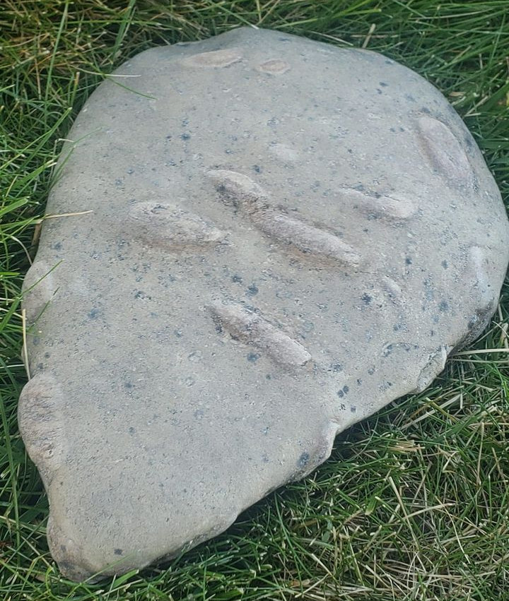
Oblate impact sphere. It is from the central OK impact. May 24, 2024.
fossil information & identification
Top contributor
· ·
Probably a concretion or nodule but figured I'd ask a group who actually knew about fossils. Found on the Canadian River in Oklahoma.
.jpg)
Colorado geology anomaly map shown above. Zebra fractal shown below found in Western Colorado by Nicole Zahniser


Another Western Colorado Fractal Specimen, found by Nicole Zahniser


The strange crater strata north of Libby Montana. You can see the the crater as mining circle NW Montana. Photo by Sandy Sonju.
Surface impacts and the mining crater shadow. While lateral impacts blast more directionally the more perpendicular type make ore distributions in a radial with larger veins of ore in crater walls or obstructions in their path. Very large impact can be disturbed by later impacts and tectonic drifts.

Column Basalt Mount Rainier, Washington USA - This is a sure sign there has been an earth crust breaking impact. It is a harmonic shock wave construct.

Fractal Boxwork, type of bricking. A high energy signature, charged phenomena as you can see from the fractal stag horn effect. It has many tiny impact spheres in the matrix. July 4, 2024.
We saw this rock in Glacier National Park in Lake McDonald while we were hiking.

Jenna Freeman, Oklahoma specimen - Fossil palm.
.jpg)
The double crater is like a central uplift only more pronounced as a crater signature. Is it a harmonic? Yes.

Christina Reed Your specimen is an impactite. The surface designs are energy dissipation signatures. They often imprint in iron or quartz a dipolar simi conductor typology. The sand is from where it impacted now fused together from shock. So why the energy signatures? Impact shock waves can end with a microwave signature also the turbulent particles generate electric charge. The circles may be pelting of shock spheres but the shock/charge phenomena can also make circles. Look at this map and notice how the topo makes the two circle rings like big impacts do. Found Dinosaur Flats.

Oklahoma Rose Rock Specimen collected by Cathy Wilkins-Carlton. This is a "Tube Wave" harmonic with secondary iteration.

<<< Perpendicular Branching Iteration

Smooth shatterconing from the Durango Colorado Crater.

Thin Plane Insertion, shredded matter ejected at hypervelocity from the impact. April 29, 2023
Paria Canyon-Vermilion Cliffs Wilderness Area, Kane County
Photographer: Trevor Schlossnagle

Shiprock NM, in the NW NM corner is an up splash coning feature, with striations. It is from the NW NM crater. May 29, 2024. Picture from
US Hiking Place ·
Shiprock New Mexico, USA
.jpg)
Durango
Farmington, NM as a crater in a crater. The average earth impact occurs at 45 degrees. People expect to see The Barringer Crater (Meteor Crater AZ) over and over. It would be like telling a doctor there is only one type of gun shot wound. Durango would be two crater walls separate in time.


Farmington, NM up splash effect. You can see the crossing harmonic along with the coning.

Up splash with crossing harmonic.
Two massive, rapid releases of carbon during the onset of the Palaeocene–Eocene thermal maximum
The Earth’s climate abruptly warmed by 5–8 °C during the Palaeocene–Eocene thermal maximum (PETM), about 55.5 million years ago1,2. This warming was associated with a massive addition of carbon to the ocean–atmosphere system, but estimates of the Earth system response to this perturbation are complicated by widely varying estimates of the duration of carbon release, which range from less than a year to tens of thousands of years. In addition the source of the carbon, and whether it was released as a single injection or in several pulses, remains the subject of debate2,3,4. Here we present a new high-resolution carbon isotope record from terrestrial deposits in the Bighorn Basin (Wyoming, USA) spanning the PETM, and interpret the record using a carbon-cycle box model of the ocean–atmosphere–biosphere system. Our record shows that the beginning of the PETM is characterized by not one but two distinct carbon release events, separated by a recovery to background values. To reproduce this pattern, our model requires two discrete pulses of carbon released directly to the atmosphere, at average rates exceeding 0.9 Pg C yr−1, with the first pulse lasting fewer than 2,000 years. We thus conclude that the PETM involved one or more reservoirs capable of repeated, catastrophic carbon release, and that rates of carbon release during the PETM were more similar to those associated with modern anthropogenic emissions5 than previously suggested3,4.

Montana

Arizona

Interesting specimen. Impactite, suspect Powder River Basin Impact or larger impact. Cone in cone forms. Melt expansion nodule with surface mosaic. High energy and rapid formation. Orogeny: Chevron forms are not associated with volcanic mafic raised form small specimens. The specimen has a melt core matrix therefore the surface is an expansion mosaic. The surface is too complex for mud drying cracks nor would mud form a rock without a high energy event as it would just dissolve back to soil. Pottery kiln temperatures are around 2,200 F lava can provide this level of energy, but this specimen is a turn on turn off fast cycle energy made form which favors impact energy. Volcanic strewn fields are much smaller than impact. There are a few thousand volcanoes on Earth. Based on Mars which has over 600,000 impacts of a mile diameter or more and is roughly half earths size the Earth has more than a million impact craters. Why is the Powder River Basin an oval if it is an impact? Deformation or lateral impact or other? The Fort Union Formation is roughly circular however the multi state basin is continuous. The Montana Badlands has a high amount of impact ash indicating a very large earth impact. Complex stress surfaces are the physical result of an accretion body.
Maryann Smith ·Feb 14, 2023·
Please help identify. I found in the badlands of Montana.

Impactite with resonate circles around center of resonance from location shown by star at right in Oklahoma. March 10, 2023
Amanda Sampson · ·
A friend found this in Checotah, OK. To me it looks like an Iron ore concretion but not 100% what do y'all think?
Kansas Crossing - Kansas is a record of many shock crossings. The big earth accretion impacts west and east are recorded in Kansas. The smaller large exploding impacts are near. First thing is to look at the geology anomaly map.
.jpg)
_jfif.jpg)


Oblate Impact Sphere. Triple stage progression. The core was formed first as a liquid drop ejected from the large earth impact. The exposed forms are called a sheet wave. A sheet wave is the physics of energy in motion on a surface, like rain going down driveway or road after a rain. It received an incomplete coating last from the ejecta splatter. June 2, 2023.
Linda Jones Floyd
· ·
I found this in our landscaping rock. I haven't a clue, but it seems fascinating how this design could possible have been "stamped" into this rock! Can anyone help? I am in south-central Kansas.
.jpg)
And here we have two impact events ash layers. The lower one is from a very large impact. I would think the back blast ash from the Silurian Extinction Event Impact that made the Appalachian Mountains.

Impact sphere with offset thin plane insertion, very rare. I need to add your specimen to my encyclopedia of phenomena as it is the only example of its type. I do have mega clast with this phenomena excavated next door as I live in a large crater.
Missouri’s Rocks, Minerals, fossils, & Artifact Finds
Jonathan Fry Oct. 8, 2022
Found today in Chariton county. Could you please help me identify what this could be?

Shock lines with grid pattern from the "Big MO" Crater. Multiple shock waves make a grid imprint. Big MO is an angled impact between other big craters. Oct. 28, 2023.
.jpg)

Impact heat mosaic nodules - The Septarian form is universal as a physics shape. The deeper impact ejecta is often bedrock strata once limestone turned into a metamorphic nodule. They are good finds. Although there is surely more than one crater in Missouri, the one called Big MO dominates the state and would be the likely candidate.
Missouri’s Rocks, Minerals, fossils, & Artifact Finds
Mike Woodward · · Oct. 7,2022
Mid Missouri find. Thoughts?
The Big MO Impact was big and bad but got covered over on parts of it from subsequent events.

Impact event fault in the lower strata. Either side could be a central uplift.
.jpg)
Old craters crossing. The Missouri/Iowa Crater centered at Lancaster and the West St. Lewis crater which was earlier Devonian.

Soils are a record of events.

Crater wall pockets for holding oil and gas.

Impactites. The top specimen is the most interesting, it has banding fractals, rare. Chert and iron, type 2 impactite with both impact surface and bolide iron. Top specimen shows the impact storm surface. Fractals are an energy form, like lightning. Banding is a resonate form. You can see the crater on the attached map (USGS Magnetic) May 28, 2024.
Jason Hays · ·
Was in Wendover and went looking for agate but these rocks was all over the place. What is this? Kinda shiny in spots. Ty.

Windover Utah shown by star, NW Utah Crater. May 28, 2024.


Walnut Canyon National Monument near Flagstaff. This is a crater wall structure, closer in type not the rubble type. It is expressing the billowing energy upward as a container vessel. The boulders on top are expelled and landed with iron from the bolide.

High shock melt breccia with black/white squiggles a type of melt isolation rejection pattern.
Saul Woolsey · June 16 at 6:42 PM ·
Trying to identify this rock found a few in colorado springs area but they might have been transplanted from somewhere else. shines pearlescent when wet.


Iron pastel refraction when wet is a nano pulverized iron of specific size to produce the "pearl effect when wet."

SE South Dakota shows exposures that indicate impacts.

The sands of South Dakota indicate several impacts. Sand itself is a byproduct of impact.

The breakup disturbance crater of NE Arizona. There was a previous bigger crater that this one slammed into. Multiple crash sites like this are a difficult forensic challenge but lets figure the Rocky Mountains were a type 2 subduction crater coming from the east. The shape of this subduction crater arc was deformed by the NE Arizona type 3 exploding crater.

TeePee Canyon Agate, Custer County, SD USA - Polymorph crystals, high resonance impactite shock agate. The red balls pictured right side are impact spheres, a shock made particle. With high enough energy these spheres are overcoming the rejection pattern sequence and melting into a violet blend. This earth impact a type 3 exploding type is centered between Rapid City and Gillette Wyoming. It is a crater around 400 miles in diameter.
The red particles are in a banding sequence, an essential levitation as they are surfing the resonance. Particle levitation has been produced in laboratories with high resonance. The next step would be melting into a solid band as energy increases.

Overshock with iron. The thin triangles are vacancy high energy cones, very rare. The thinner the triangle the more energy was involved. It is a coning gassing void, a type of mosaic heat surface. It is intriguing that the left one skipped a section and then made an inversion of the cone as a disintegration form. The overall surface is a high shock metamorphic with cavitation and misted iron from the bolide iron plasma cloud. A rare and remarkable specimen.
strange find I.D., geology, archaeology, paleontology, Native Artifacts
Kayla Vandal · Oct. 13, 2022 ·
Found in a section of a huge pasture that was "rough country"/barren/ badlands type terrain in SD. I've done a ton of research but I am eager to hear your thoughts on these items. Thank you!

Tobias Fousek · Oct. 20, 2022
Small chip about 1inch long that I found just laying in the pine needles in Teepee Canyon, SD. It is small but finding float and not having to mine or break rocks is great. This is the first I ever found and I love the pattern and the bots.
Shock Agate, Quanta Circles, energy form shifting. As an isolation form the resonate shock energy is making the dots, then a second surrounding energy circle, then it jumps into a third dimension making the bubbling spheres.

Christel Brown · Oct. 26, 2022
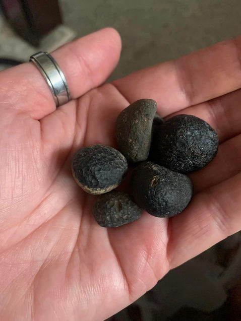
Found these curious little rocks on Medicine creek at Ft Sill OK.
They don't scratch glass, a steel nail does and leaves a powder behind. 3 are round. One is broken and inside are tiny pinkish and blackish crystaks and dirty Druzy quartz, I think. They feel chalky, but nothing comes off by handling.
Any thoughts? Thank you!


This specimen is a dissertation of rejection patterning. A high shock type 2 impactite containing both impact material and impacting bolide material. It is a meta form and Splatterform with rejection patterns at two levels. The inclusions arrived from closer to the center of the impact as there rejection patterning is higher shock. The specimen while containing linear Constellationing as a rejection pattern also has some larger "false strata" or strata larger linear striation in the top left bits. This could be a larger shock wave imprinting (false strata) or sediment lines. The extreme indention of the inclusions indicate it was very hot and has isolated around these inclusions as a cooling differentiation mosaic. While it does have a small section in upper top right side that appears to be a shallow ablation surface the overall presentation is not a meteorite. As for specific impact orogeny only a very large earth impact could have made this specimen. Primary suspect crater would be the Navada Basin Crater. Large Ordovician Crater.
Rocks and Minerals - identification and information
Vivian Wagner · Dec. 9, 2022
I think this might be some sort of collection of fossils embedded in sandstone? Found outside of Pahrump, Nevada.

Type 3 Impactites, impact sphere variants. You have found one of the Nebraska Craters. These are formed as a liquid and ejected as drops. A type 3 impactite is one made of the impacting bolide material.
· Dec. 13, 2022
Interesting lil things..


Impactite, opal with cavitation and impact geometric. Few people have ever seen an impactite with cavitation much less an opal one and the hexagon cavitation is over the top. Carnelian surface of the cavitation indicates this cavitation was produced by the plasma bubbles of iron in hypersonic flight as ejected from crater. The opal indicates water was also present at the time of impact. Hexagon cavitation is produced by the bubbles surrounding pushing back when formed. Opal versus Chalcedony/Tektite types of impactites: First the overall sheen of this specimen is diffusing light, while not excluding chalcedony it broke too easily as a chalcedony/tektite would be much harder to break. (revised July 1, 2024)
Jesus Gomez Morales · February 6 2023 ·
Found this rock in an old trailer in Yuma Arizona , it called my attention and especially the bottom clean cut i broke it in. Half and I found what ???

Crater wall "Void Coning." The shock energy in a triangle wave as it ran out of material to imprint coning.
Don Alesi · Feb. 18, 2023
Not exactly something you can put in your pocket but this hollow rock formation was really cool during a steep snow shoe hike this morning. Saw some animal tracks leading to it so we didn’t get closer. Near the Pactola reservoir in South Dakota.


Rare Impactite. Cone in cone shatter coning, striation type. Jasper type banding a cross harmonic of shock wave imprinting and mineral resonate refinement. Surface mosiac splatter melt of quartz in white a milky quartz. Citrine with high iron content Fe3O4 SiO2.
LouAnne Smith
All the same rock I found this morning. Its rough In texture topaz color is like agate . There is a bit of sparkle on 1 side . Is that a tail of some sort of fossil? The little bits of black is shining to. I really do not know what this is. I found in my landscape rocks in Egan South Dakota

Popcorn agates, a type of impact sphere or nodule that is bubbling milky quartz, probably was once sand. Fairburn, SD. Chris Ficek

Impactites all, Perrie Crater. The Perrie Crater can be seen on the sand soil map of SD. While the glacier top modification has distorted the crater it is still evident. Your specimens have a compressed ash, nano burnt iron and crypto crystalline silica composition. The cubic specimens are a high heat mosaic where the whole body of the specimen is in a cooling cracking. The crypto crystalline chert (SiO2) specimen exhibits two energy signatures. The top marked 1 is a type of Turing Pattern (Alan Turing 1952). Turing patterns are a "rejection pattern sequence." A rejection pattern sequence is a state of energy and the response of dissimilar materials isolating. The second (2) is an energy signature, a coning fractal charged leaking attempting to ground or connect, caught in this incomplete state. It is not a harmonic like "shatter cones," but pure energy. The energy was created by the impact explosion turbulence of so much nano material. While not an electro magnetic pulse it is a state where high active charge would prohibit any electro magnetic wave from passing as this energy would become part of the diffused energy like chaff in WW2. Could this physics be made into a weapon or counter measure? Yes. It would make a good proposal for 6.1 Basic Science research. May 4, 2023
April Bebensee · ·
Here's a quick look at some of what my son and I found last weekend in the Pierre, SD area while hiking!
He's hook and I'm loving it!!!!
Our dining room table is covered in our finds!
We have no idea what most of them are. Does anyone have a good book they'd recommend for some beginners (my son is almost 11 years old)


The arrival of secondary splatter. This happened while the specimen was in a mosaic cooling state.

Impact mega clast from the Great Basin impact. Large size breccia inclusions. Impact breccia is usually not this size but this is from a bigger size impact. May 16, 2023.
Amy Jo ·
Found this half buried in the desert North of Las Vegas, NV. I think it's lime stone but the patterns on the surface have me bewildered. Any ideas?
Top contributor
Impact nodule formed hot with also hot impalements. The blue could be cobalt I cannot tell from the picture however. Shock made dolomite is very heavy as the shock compresses it. The limestone type are ejected from the strata the meteor hit. The blob shapes are a function of the melt. Aug. 1,2023.
Tammie Edgerton
Found in Northern Montana. Any ideas?

Type 2/3 subduction/Exploding crater. Big low angle impact from the northeast.

Surface topography can be difficult considering the limited knowledge of crater types and the one theory of tectonics. Notice the arc directly below the central uplift/retarc. Also consider that this is not a laboratory experiment. Impacting bolides are not uniform nor is the surface where they hit. The subduction can even cause a flare off as seen in the NW as the energy is expended deeper below ground. Also subsequent impacts will scar these large craters as large craters are earlier as shown between arrows.
.jpg)
Notice how the earthquake shows the rubble epicenter. As a NE subduction this shift is a reflection of the disturbed lower strata still trying to resolve stress. It is not plate boundaries. You can take two sheets of paper and never make a circular fault system by ramming them together. Aug. 1, 2023.
.jpg)
The mining map shows the same offset as the earthquake epicenter. The rubble also gets the exploded minerals from the bolide. You can also see two more possible craters in the southern edge of the state.

You can see the exploded fragmented nature of this impact on the magnetic anomaly map.

The Medicine Bow WY Crater. This is an angled impact from the west. Craters this large express a deeper signature on a gravity map therefore not a complete circle.


Big crater effect, shock bricking. I see this here in the Howell, TN crater and yes it appears to be man-made but will be found in the most obscure places. Here in the Howell crater, I first observed it in small creeks entering the Elk River not a place anyone ever built a wall. BTW in your location it is surrounded by impact ash calcium bentonite. This ash was once limestone but burnt and blasted outward. The physics of impact bricking goes like this. It is a sub type of "false strata." The lateral component is the shock wavelength imprinting in the resident strata or compressing the ash into shale. As a wave harmonic stalls at its crest that breaks the strata as an imprint. The vertical component of bricking is the materials inability to absorb this energy and it breaks to the weak lateral lines which is why these breaks are not a continuing linear to the next lateral line and are unevenly spaced. Your second picture also has impalement holes as explosion is a progressive process. The red surface is the plasma iron which falls as a mist and welds to surfaces, these are often the last effect in the forensic physics analysis of your location. Attached in the USGS gravity map for WY with the big Medicine Bow two craters the upper and smaller lower. Either one could have made your location but the high volume of ash indicates the larger, but this could be a two step process with the ash from the bigger impact and the compression and bricking from a later impact. Aug. 29, 2023.
Geology
Opinions on this formation I came across in Southern Wyoming, USA, This was near Seminoe Reservoir and the Seminoe Mountains.

Topo view of the Medicine Bow Crater Complex (MB3). The interaction has rearranged the walls but the larger craters are likely older. Aug. 29, 2023.

Blast strata feature very directional. May 24, 2024.
Wyoming Geological Survey
Wall Creek Sandstone near Casper.

Clastic pipes as an impact produced sparce column basalt type. Column basalt as a compressed moving bubble from large Earth crust breaking impacts shift the round tube to a geometric shape depending on the number of adjoining compressing tubes. These tubes not joined would be cylindrical. Impact would also explain the accompanying breccia. Sept. 3, 2023.


Clastic pipes are found centered around the core of the proposed four state crater. What are the odds of that? Sept. 3, 2023. Picture is from:
Sedimentary Geology
Volume 344, October 2016, Pages 20-33
Clastic pipe characteristics and distributions throughout the Colorado Plateau: Implications for paleoenvironment and paleoseismic controls
Author links open overlay panelD.F. Wheatley a, M.A. Chan a, D.A. Sprinkel b
.jpg)
Devils tower Wyoming, and the ending turbulent break up of the up splash energy. Narrow tapered coning is the shatter cone being expressed in the column basalt. Sept. 4, 2023.

Wyoming as a classic crater expression however quite large. The Black Hills would be the central uplift. Devils tower would be a part of the central uplift like Iceland is to that very large crater. Illustration is from the Wyoming State Geology Survey. Sept. 4, 2023.

Clastic pipe, tube wave, mullion form Barnhardt Canyon, AZ. Same crater, the four state crater. Sept. 6, 2023.
GLG310 Field Trip Photos by Josh Coyan.

Outward crater wall blast expression. Hanksville, Utah. Sept. 7, 2023.
Brète Thomas · · Utah ·
San Rafael Reef along the southern perimeter of the San Rafael Swell near Hanksville Utah USA. I just love flatirons. So how do these form? I'm guess some type of plate shift and the water erosion creates the triangular shapes? — at Capitol Reef National Park.

Big old subduction crater a type 2 made the Snake River Basin. Magnetic anomaly map. Sept. 10, 2023.
.jpg)
Thermal map showing the big type 2 Idaho Crater and the South Colorado type 3 exploding impact crater but it must have gone deep enough to affect a crust temperature change. So that would make it a type 1 having broken the Earth's crust. Sept. 10, 2023.

The big type 2 Idaho subduction impact as shown on the USGS Gravity Map.

Vertical energy striated up splash at Yellowstone, WY. As a kinetic harmonic it is in several wave energy expressions with the larger in the core and getting smaller toward the outside. This is the same type of up splash energy expression as column basalt just not as well formed into tubes. Aug. 11, 2023.
Geology
Saw this formation at Yellowstone. I don’t understand the drastically different layers, how does this form? Yellowstone National Park, Wyoming, US

Anytime you see watersheds that form circles and arcs look for the crater. May 30, 2024.

Ending energy configuration. Pulsing sputtering of this up wave splash with limited exposure of it. Aug. 11, 2023. Yellowstone, WY. USA. Same photographer as above.

The picture is not volcanic. This is the up lift splash of a large earth impact. The Bear's Paw central uplift is from a type 2 angled subduction crater which came in from the NE. A big impact does not have to make a circle crater as its relative physics is more powerful. The average angle of impact is 45 degrees. It is the oldest of the three craters pictured on the attachment. Sept. 20, 2023.

.jpg)
The Bear's Paw subduction is Montana Geology as shown on the attached illustration of Montana geology. The west side is the crater signature with the weaker shock harmonic on the east as this is a high relative to earth energy expression. Sept. 20, 2023.
.jpg)
Faulting. Bear's Paw has a clear crater signature in the central uplift but the crater edge west is speculative as the angled type 2 subduction can flair off losing the arc signature in these type craters.

USGS gravity map. The shows the deeper contour of this large crater. Montana is just part of the crater as the upper crater is in Canada. Sept. 20, 2023.

Chief Mountain is a deep upward thrust from this impact. Pre Cambrian crust shot upward like a splinter in an explosion. Sept. 20, 2023.

Oblate impact sphere conglomerate. It landed as a still molten blob and welded to the gravel. Rare. Sept. 25, 2023.
Shauna Barnum · ·
Does anyone know what this could be? I found it in Montana and have had it for many years. Its one of my most favorite finds. It is hollow…there is something rattling around inside it. It weights 6.7 oz.


North Dakota, impact spheres, Teddy Rosevelt National Park. There is a big old crater as well as many smaller craters and a western arc indicative of an even older larger crater. USGS Isostatic gravity anomaly map. Oct. 10, 2023.
Kristi Weaver
Teddy Roosevelt National Park has concretions as well.

Impact coning with iron plasma rain, from the four state crater. Oct. 12, 2023.
Brète Thomas is at Grand Staircase-Escalante National Monument.
· Kanab, UT ·
The most bizarre rock formation I've ever seen. (I posted a wide-angle photo in the comments) Look at that purple! I've never seen that color in nature. I was so surprised at the photo, I loaded it onto my phone and hiked over there to make sure the color was right. And almost pure white rocks sandwiching this layer of vivid purple.
#geologicalwonders #bizarre #utahisrad #hikingadventures #desertlife


Up splash feature near center of four-state crater. Grey impact ash is expelled with the impact ejected projectile. Oct. 17, 2023.
Arizona Geological Survey at the University of Arizona
·
Miocene-age (?) igneous intrusion (Ti) exposed in Red Rock Valley, south of the Carrizo Mountains on Navajo Tribal Lands in Arizona. The Walker Peak intrusion crosscuts the Triassic Wingate Sandstone (Trwr) and the older Church Rock and Owl Members (Trcco) of the Chinle Formation. The butte rises over 700 feet above the adjacent Triassic sedimentary rocks. A potential NE-SW trending feeder dike – not in view - crops out at the northeast end of the valley. Coordinates 36 degrees 38’ 49.84” N, -109 degrees 08’ 08” W.

Shock agate/popcorn from the SD Retarc. Shock melt mosaic type surface which is bubbling a botryodial form (A botryoidal texture or mineral habit, is one in which the mineral has an external form composed of many rounded segments, named for the Ancient Greek βότρυς (bótrus), meaning "a bunch of grapes") The matrix is mixing much like mixing paint in a can. Other beautiful shock agates can be found in this area. So, you are asking what is a "Retarc?" A retarc is crater spelled backwards. These craters make only a central uplift as they explode too deeply for the traditional crater ring structure. Here is a nice picture of it attached.
.jpg)

Polymorphism, pseudo morphism, twinning, planar deformation features, resonate alignment - First the provenance of where found is an overlapping of more than one crater but one is enough. The attached picture shows one that broke the Earth's Crust, called a "Crusta Confractus (CC)." The joke in physics is the assumption of the simplest case. Explosion physics is chaos and multiple direction shock is normal. That explains the offset directions as you can see this when a water wave encounters a barrier and bounces back on the original wave. Another physics that is poorly understood is that polymorphism, pseudo morphism, twinning and resonate alignment are all the same impact physics phenomenon. They are just differing expressions of a common cause with resonate alignment being the overarching principle. See all the dots in your specimen. That is more important than is ever considered. These small particles are from the impact particle storm. If they are all the same size that is called the "common particle" which has been sorted with distance. It is also the tons of micro meteorites that fall by the ton each day on Earth. The particles align by attenuation to the shock resonance imprinting the wave lengths. As the particle dispersal in chaotic some lengths of the wave imprint go unprinted. I hope you don't mind if I add your specimen to my encyclopedia of impact phenomenon. Signal Peak AZ Crater. Oct. 17, 2023.
Field of view= 2 mm. Alamo breccia from Tempiute Mtn. Cleat-like fracture pattern. Any ideas?


Impactites from the "Great Basin Crater." Most interesting specimen with the chert horn attached. This is a type of splatterform but rare. The matrix base is also somewhat uncommon having a turbulent grain structure and fossil inclusions. I hope you don't mind if I use your pictures as examples like this are instructive. The crater can be seen on the USGS magnetic and gravity maps. While the magnetic map shows the central core of the impact the Gravity map is much more interesting. The famous joke in physics is the assumption of simplest case but as you can see what happened is the density of the impacting bolide is not uniform making what resembles two impacts at the same time. Oct. 22, 2023.
Jill B-Macintosh · ·
Three rocks all found in southern Neveada, US, by my late husband. Middle one was cut and polished by a friend of his. He worked in this region from 1991- 2005 and traveled the entire region from the Utah/Arizona Strip state lines to California on the south and west side. I do remember the bottom rock being found just outside of Las Vegas around the Jean Dry Lake. Would love to know what they might be. Thank you.


Love that picture, may I use it? Impact sphere impalements into a shock made viscous liquid surface. Is really a sci fi shot with you as some elongated alien. Oct. 23, 2023.
Chris Plastow
Please could someone explain this pattern, please .
It’s in Utah USA , definitely sedimentary rock , that’s all I know .

Crater clusters of Utah as shown on the Chegg Products and Services gravity map.

Mid state Utah, Impact Conglomerate Layer. Oct. 26, 2023.
Cretaceous-age conglomerate deposited during a mountain-building episode 75 million years ago. Maple Canyon, eastern San Pitch Mountains, Sanpete County, Utah.
Photographer: Don Clark

This is an impactite (large earth crater rock). The phenomena exhibited is an impalement. The chert matrix (a matrix is the dominant body of a rock) has been impaled by the quarts impact sphere/simi sphere as we do know if it broke at the time of origin or later. The quartz has a triangle which is a crystal pseudomorph as it was formed too quickly to complete the cubic structure. The radial lines called an eyelash effect are due to the impact of the quartz inclusion as the matrix was still pliable. The black is black iron oxide Fe3O4 which came from the iron ore in the impacting bolide/meteor. This can fall on impactite as a mist from the plasma impact core cloud and bond. The four-state crater dominates this area and could be the causal impact, but earth has over a million impact craters and each state an average of 2,000. Let's take a look at the four-state crater (attached). On this gravity anomaly map (Chegg Products & Services) you can see the dense gravity central uplift crater core and the surrounding blast material ring although broken up in density. On a surface topology map the crater is centered at the four-state intersection so we can determine the impact direction coming from the NE as gravity anomaly is a deep look at the earth's surface. Nov. 10, 2023.
This was found in New Mexico in the U.S.
I am curious about the perfect circle in the stone. It has a real nice sparkle to it when it is in the sun and in the edge a bright shine almost like a diamond. Around the circle, the coloration of the rock is black.
I would appreciate it If we could id this awesome rock!


Let's take a closer look at Utah using the magnetic anomaly map. Old crater remnants in the state corners. Nov. 11, 2023.

Impact ash layer progression. Nov. 12, 2023.
Spokane Formation, Glacier National Park, Montana. (credit: Marli Miller Photography)

Shock circles, Thermopolis, WY (mid-state).

As shown on the USGS magnetic anomaly map, WY is a state with a record of concentric bombardment. Is this one large crater with angled disintegrating rings? I rather think many craters, but there is a very large multi state crater centered east that crosses SE WY. Dec. 8, 2023.

Impact sphere/nodule/mega clast - Big earth impact. This is called a bowl type. Jan. 4 , 2024.
Geology Identification
Ashlee Nave · ·
Anyone know what this is?
Southern Colorado
Approximately 4’ tall


Impact boxwork type 1 shockwaves crossing grid. It also has some fractal ending breakup of the wave imprint. The western four state crater. Jan. 7, 2024.
Brent Peltier · ·
I found this 35 years ago in the desert,near the rio verde river in Arizona,
Any thoughts on what it is?

Impactite, from Idaho 3 Crater Confluence. This is called impact hieroglyphics. While the human brain is biased towards seeing human forms, etc., what is really interesting is the row of chain circles. That is not common. It is a repetitive resonance, like something you might see on an oscilloscope. Note the trace iron on top right side. That is from the meteor/bolide. The lower banding is a flow pattern as this was formed in a liquid state. The silica matrix may have once been sand. May 30, 2024.
Julia Plitt Chase · ·
Looking for opinions on what this may be. What's yours? Man-made, nature made etc... ? Found in the northfork of the Couer d'Alene River in Northern Idaho


Rejection patterns with tube sealing itself off at end of flow. Jan. 13, 2024.
Couer d’Alene ID

Specimen was found at the confluence of three craters. Jan. 13, 2024.

The Western Four State Crater looks to have been a Carboniferous Period Event. It is a rather large crater to have occurred so late. Jan. 19,2024.

Impact shifting structure, White Pocket, AZ Peter Pallagi This is part of the Western Four State Crater. White Pocket is on the border upper central AZ. Explosion wave patterns - First the up down columns are sinusoidal and striated. This GPa is similar to striated Shatter Cones which occurs at the lower range (2 - 30) as the higher range loses it striation and melts together smooth. Banded striation - This indicates a resonate harmonic in which the minerals are attenuating at different harmonic frequencies i.e. silica versus iron. Crossing geometric patterning - A wave form grid is the overlapping of similar size wave lengths. In an explosion the shock bounces off and makes echo shock waves. Jan. 20, 2024.
Multiple shear breaks, iron particle surface inclusions. High heat mosaic, energized constellationing, granular crystal habit, a rejection pattern, indicating it was in an energy state.
Vectored sheer breaks while forming orogeny or later? Notice you have a mosaic crossing stich which indicates this all happened together. The left column has a mosaic eye figure in both black and white a curious phenomena of multiple active forming orogeny. This is part of the western states four state crater.
Jan. 20, 2024.

Coning and mosaic heat cracks. Coning shown in left side marked 1. Mosaic heat cracks are a large scale and shown marked. 2. Jan. 20, 2024. Same location and photographer.

The Topo Craters of Colorado, USA. Jan. 26, 2024.

Interesting piece of impact sphere with melt dripping flow. Jan. 26, 2024.
Celeste Henderson-Chaloupek · ·
Found in SW Ks in river bottom.

Magnetic map from Kansas Geology Survey.

Impact sphere conglomerate. Small spheres typically indicate a smaller crater, less than 20 miles diameter. Various size cluster indicates the specimen was made close to the impact. While the specimen does have trace iron from the meteor/bolide it is largely surface material reformed a type of metamorphic. Based on Mars the typical US state has about 2,000 surface craters of a mile diameter or greater. So why are there only 200 official craters recognized in the world. Serious crater hunters disregard the official crater system. It is an unfunded failed process based in Canada, you know the place the unhappy with the election celebrities are moving to
Shannon Crouch
Its limestone, was found in Mitchell County.

Mitchell, County, KS

Mushroom Rock State Park in Kansas. Impact sphere. Notice the energy flow patterning on the rocks shown right. That is a type of shatter coning phenomena with the steep triangle wave pattern. Jan. 26, 2024.

And there is the crater as shown on the Chegg Products & Services geology anomaly map. Jan. 26, 2024.

San Raffel Wedge, Utah. So lets revisit Utah. Here is a nice picture showing the triangle points again as was shown above when asking where do the triangle points come from? Raft/Plate Tectonics cannot explain this. It is as simple as taking sheets of aluminum foil in you kitchen and ramming them together and see if you can make uniform triangle points in a row. You cannot. That is how theories fail. The triangle points are simple upward energy in excess of the moving earth a coning form like shatter cones. The alternating minerals are banding by shock attenuation either during this event or a previous one. So let's take another look at Utah with Topo map. Feb. 24, 2024. Photo by Rob Little.

The big western states four state crater goes through Utah from the SE, but the San Raffel Riff (shown as star on above map) is from a smaller crater. Now it does not matter if a crater is only partially present or was not round to start with. Just like with your aluminum foil experiment you will not be making arcs by raft/plate tectonics. Based on Mars the Earth has about 2,000 surface craters per state so this is not all of them.
Wiki overview. The San Rafael Swell is a large geologic feature located in south-central Utah, United States about 16 miles (26 km) west of Green River. The San Rafael Swell, measuring approximately 75 by 40 miles (121 by 64 km), consists of a giant dome-shaped anticline of sandstone, shale, and limestone that was pushed up during the Paleocene Laramide Orogeny 60–40 million years ago. Since that time, infrequent but powerful flash floods have eroded the sedimentary rocks into numerous valleys, canyons, gorges, mesas, buttes, and badlands.
Crater distortions. As you can see on other planets and our Moon crater become distorted by subsequent impacts. Also surfaces are not always flat and uniform nor are impacting meteor/bolides/protoplanets/comets/asteroids round. That is why I say all impacts are unique. Additionally angle of impact does affect crater shapes. Large or fast impacts can subduct the crust making what is thought to be raft/plate tectonics but is really impact tectonics. Feb. 24, 2024.

Meteorite or impactite - Flow lines. Notice how the top is just etched but the sides are linear. It even has an indention also etched. Tektites are an impact glass and this is a ferro silica. Not easy to etch. Having said that the physics of origin are the same, i.e. impact. So why would the etching be different on a meteorite versus an impactite? A meteorite has a limited energy to mark its surface and often the surface differs from its matrix like the fusion crust. This specimen appears have been hot all over but surface etched by a high velocity particle storm like in an impact. This storm was faster than earth entry which can vary from 10 to 30 miles per second. On the other hand impact ejecta can double its impact speed making the impactite travel up to 60 miles per second. Which would also be the speed of a particle storm. Was this from an Arizona or a California impact? The magnetic map of AZ shows a crater that appears to have hit from the west but encompasses the border area. See attached. March 5, 2024.
Phil Thompson · 15h ·
Need some help, is this Tektite? From Ca/Az border


Impact Spheres, Theodore Roosevelt National Park, ND, USA. I know I showed a small crater nearby above but these spheres are too big for that crater. USGS magnetic map shows 3 big craters nearby, one of the larger 2 probably made these sphere. March 15, 2024.


Round Impactite Spheroid, hematite fast formed concretion. Same forming dynamics as Tektites. The iron is from the impacting meteor/bolide. While they can travel far as a forensic method I always start with where found is a crater. March 16, 2024.
Karen Gee
Wyoming
Anyone know what this might be?


Carnelian Splatterform with impalements. Uncommon.
Dan Bennett
(I am Groot!) 19 1/2” Eden Valley limb with agate cap. Green River formation, Sweetwater County.

The right crater is similar to the Barringer Crater in AZ a square crater. The left crater is a crater "retarc," an uppie where the explosion happened deeper. It is also a slider from a lower angle impact. March 19, 2024.
Dan Bennett · ·
(I am Groot!) 19 1/2” Eden Valley limb with agate cap. Green River formation, Sweetwater County.

But wait, that is not all it is a four crater county. What appears to be a slider is a small crater. Look how nicely the SW crater made and banded the coal. I wonder if it has diamonds?

And there they are. But now we can see the whole state and other bigger craters. March 19, 2024.

Clean Cavitation Impactite - Not common. Most impact cavitated impact specimens retain iron from the iron plasma. This appears to have once been limestone bedrock, now shock hardened dolomite. Random cavitation versus flow cavitation - Meteorites have flow cavitation as they are cavitated by directional entry into the Earth's atmosphere. Impact explosions are random chaos as seen on this specimen. Attached are a couple of small craters of NE Kansas. March 20, 2024.
Kirk Iseli · ·
Found this several years ago in Northeast Kansas. Can’t tell if it’s something like a very crudely made drill, or a naturally occurring Leaverite. It was, however, found in the immediate area of other easily identifiable artifacts, much better looking than this. I’m leaning towards the idea it was someone’s first attempt at flintknapping a tool lol.


Impact Conglomerate, NE Kansas. Now here is iron from an impact. See the little red iron speckle dots? That is impact particle inclusions. The iron matrix binder is also from the impacting bolide/meteor. March 20, 2024.
Carolyn Brown · ·
Iron Oxide with sediments. NE KS

Impact nodule cindering. Again, NE Kansas. March 20, 2024.
Kansas Rockhounds and Fossil Hunters
Chip Collins · ·
Walking through the dry/runoff creek bed I found this barely poking up above the silt. NE KS LVCO

Suevite, impact melt breccia (broken bits). Lovely specimen. March 20, 2024.
Kansas Rockhounds and Fossil Hunters
Carolyn Brown · ·
Fortification agate with lots of platelets, Paint agate, Honey agate with some cool exterior crystal impressions, agate in host, (Ryolite) and Brecciated Jasper with druzy quart filled vugs. NE KS

Garnet flow - Look how the black lines are going around the garnets. The impact made garnet impalements and the lateral flow were about the same time. March 20, 2024.
Doria Skinner, specimen. NE Kansas.

More Impact Breccia, Christi McMillen, Ford County, KS. March 20, 2024.

Here are a few of the many craters shown on the Magnetic Map of KS. March 20, 2024.

The Cloud Creek, WY Impact Bombardment - Cloud creek has been drilled for oil/gas and has seismic mapping. It is however a part of many impacts. March 21, 2024.
Cloud Creek structure, central Wyoming, USA: Impact origin confirmed
2003, Meteoritics & Planetary Science

Here is another WY impact storm. March 21, 2024.
FEBRUARY 14, 2022
Secondary cratering on Earth: The Wyoming impact crater field

Impact Spheres, Big Horn Basin Crater, WY. March 25, 2024.


Look at that interesting coning. NW New Mexico. April 30, 2024.
Steven Brown
Hi, new here, first post. We recently moved to SW Colorado and have come across many really cool pieces on our hikes. I thought this one was unique, in the Ah-shi-sle-pah wilderness area in Northern New Mexico

NW New Mexico Crater Gravity Circle. April 30, 2024.

Thank you for posting this strata. It could be mined as decorative stone. Let me offer a few ideas based on forensic physics and impact tectonics. Sand pushed around and as sandstone into hills and even mountains needs a mechanism to be a solid and up so high. The slow pressure of sediments does not lend itself well to this terrain difficulty. Well then you have raft/plate tectonics, an interesting shadow theory like Plato's cave. You can easily disprove this theory with sheets of aluminum foil at your kitchen table. Push them together and they crinkle but do not make circles.
Next is the idea that toxic minerals condense out of earth seas. Chemical condensates or precipitates tend to be salts.
This is contrary to the continuation of fossils found in all of these time periods. It is an old theory dating back to the 1800's originally called "spring release" from some earth crack and later renamed Mississippi Valley Type (MVT). No such crack has ever been found to source this theory after more than a century.
Lateral flow and step cracking or bricking is a phenomenon common to impact. Shock of high magnitude makes matter liquid and presents with wavelength layered step banding cracks which as so powerful the cracks are joined vertically by the excess energy. Iron and cobalt are common to impacts and present as surface ores. They are from the impacting bolide.
The physics of this presentation are easier to explain with impact tectonics than with sedimentary raft theory. This stratum is from a big crater shown on the attached link it is large and takes up the NE state crossing over into South Dakota. May 3, 2024.
Wyoming Geological Survey
·
Geo-Note! This heavy-mineral sandstone outcrop is exposed near an unnamed tributary of Black Butte Creek in Sweetwater County. "Heavy" minerals like ilmenite and zircon are denser than quartz. Flowing water—in this case waves on a beach—sorted the sand grains by density and deposited the heavy minerals together.

Crater directional axis and wall deformation record. Note the fractal alignment. This is the angle of impact. Fractals tend to branch away from the energy source, hence a SE impact. These fractals form fractal cones a remarkable phenomena as a shatter cone writ large. The western wall has been deformed by a later big impact. May 3, 2024.
Wyoming State USA 3D Render Topographic Map Border is a piece of digital artwork by Frank Ramspott which was uploaded on September 18th, 2017.
Wyoming State USA 3D Render Topographic Map Border
3D Render of a Topographic Map of the State of Wyoming, USA.
All source data is in the public domain.
Color texture: Made with Natural Earth.
http://www.naturalearthdata.com/downloads/10m-raster-data/10m-cross-blend-hypso/
Boundaries Level 1: USGS, National Map, National Boundary Data.
https://viewer.nationalmap.gov/basic/#productSearch
Relief texture and Rivers: SRTM data courtesy of USGS. URL of source image:
https://e4ftl01.cr.usgs.gov//MODV6_Dal_D/SRTM/SRTMGL1.003/2000.02.11/
Water texture: SRTM Water Body SWDB:
https://dds.cr.usgs.gov/srtm/version2_1/SWBD/
by Frank Ramspott

While not sitting in a large cobalt deposit there is noteworthy cobalt in the area. May 3, 2024.

What is more indicative of this crater than trace amounts of cobalt is uranium. See the circular deposts made by this impact explosion. May 3. 2024.


High states of impact shock melt. The first two pictures are of the same specimen. These boudin inclusions are melt droplets in a matrix. The wormy looking specimen is the same only more densely packed with scattering elongated droplets. The black and white specimen is an impact made agate but with low resonance. It is in more of a high melt state. Of the three specimens it is the closest to resembling Suevite but does not have the variety. May 4, 2024.
Elaine Flores specimens found in Big Horn country.

The cold craters of Wyoming. Like the other geology anomaly maps you can have high or low crater outline identifications. The large horseshoe shape in the top of the state is the Big Horn Country Crater. It has left an oval footprint thermally.
But look at that Texas through Alabama and Florida arc. I did not realize the Gulf of Mexico crater did that much crustal damage that far inland. Wow that was an earth shaker.
May 4, 2024.

Dragon Stone Septarian, impact iron/manganese ore from Hell Creek Impact Crater. A pure type 3 impactite made of only the impacting bolide material. The surface Septarian effect is from the dense ore attempting to bubble. In the top right you can even see a half bubble with collapse wrinkle. See arrow above. May 25, 2024.
Eugene Priebe · ·
Can anyone help identify this for me?
I know it was originally found near Terry, Montana and is roughly the size of a football.

Here is another Dragon Stone Septarian with blast flow directionality. May 25, 2024. Fossilera.com

The Hell Creek Formation Impact Crater. May 25, 2024.
Map of the Hell Creek and Lance Formations in western North America
Lamanna MC, Sues H-D, Schachner ER, Lyson TR - Lamanna MC, Sues H-D, Schachner ER, Lyson TR (2014) A New Large-Bodied Oviraptorosaurian Theropod Dinosaur from the Latest Cretaceous of Western North America. PLoS ONE 9(3): e92022. doi:10.1371/journal.pone.0092022
Exposures of the Upper Cretaceous Hell Creek and Lance formations in western North America. Scale bar = 100 km

The Hell Creek Formation Crater is much bigger than the circle shown above. It broke the Earth's crust (Crusta Confractus) and left that signature. In this view it appears to have come from the SE. Low angle (less than 45 degrees) and larger impacts release the explosion force on one side of the forming crater with a distinct higher energy level on the touch down side. So, that would be consistent with the impacting bolide coming from the NW May 25, 2024. A 250 mile crater, bigger than Chicxulub.

Shiprock NM in the NW corner of state and the San Juan Basin Crater. This is an up splash feature making striated coning (shatter coning). The crater is visible on coal, gas, geothermal and uranium mapping. May 29, 2024.

The San Juan Basin Crater is also still visible on topo maps although like the moon and the other planets craters get mangled by other craters. Besides being in several larger craters it has been pushed from the east. May 29, 2024.

Iterative pulse impact sphere. You can also see that it is coning, a progressive shorting of the forming process. It is like running with a bubble wand where a multiple bubble will be connected to smaller bubbles. SW Wyoming. June 1, 2024. Terri Walford ·

USGS magnetic anomaly map of WY. The SW corner crater is very clear on this map. The dot circle crater, is interesting, perhaps a crater perhaps not. June 1, 2024.

Cobalt and manganese dendrite fractals a fast formed impact expression, like lightning. Green River SW WY. Lloyd Meeks specimen. June 1, 2024.

SW WY Crater Confluence. June 1, 2024.

Impact tube - Impact sphere elongated by high velocity. It has iron and iron blast bits in the core. The core resonated the separation of the iron which is denser. The tiny grain structure is the pulverized impact material shock pressure compressed into a rock. Attached is a geology anomaly map showing some of the craters of central AZ. June 8, 2024.
Lisa Rachelle · ·
Update: my son told it will break so he threw it on a assault and a piece did break off. Son said i wasnt strong enough lol. Anyways i took more pics of it. And he will not b touching it again lol
Found this up in payson next to the river. It is hard as a rock u can drop it and it won't break. What are your thoughts on this? Personally I think it's one of those dog sausage roll treats. But the hardiness is throwing me off lol and my dog has no interest in it


Twinning Impact Phenomena, June 8, 2024.
Ann's Rockin Adventures Between a Rock and a Hard Place · ·
Hello again fellow rockhounds and crystal lovers!
The other day, I posted some of my "Payson Diamonds," which are double-terminated Quartz crystals found at Diamond Point near Payson, AZ. The ones I showed you were not my best finds from that location, they were the less perfect ones that I don't display.
This is one of my favorite finds from there. It's champagne-colored, double-terminated Quartz, with perfect points that are Amethyst. It has, what looks like, a flower, on one side. It's amazing from every angle! This one gets displayed in one of my acrylic wall shelves. I absolutely love it!
#quartzcrystals #amethystcrystal #amethyst #doubleterminated #doubleterminatedquartz #crystals #crystallove #paysondiamond #selfcollected #imobsessed

Impact conglomerate Agate, Chalcedony. June 8, 2024.
Peggy Fisher
Top contributor
· August 5, 2023 ·
I Found this in Payson Arizona, any ideas on what it is? Please and thank you.

Impact nodules and spheres, a very nice collection of variants. June 8, 2024. Peggy Fisher collection.
Payson, AZ and Payson, UT are both great rock collecting spots. Now to Payson, UT. June 8, 2024.

Suevite boulder and impact sphere. You can see the impact craters of central UT on the attached geology anomaly map. June 8, 2024. Blake Hudson, Payson, UT.


Impact Erratic's, Tether Rock, Kansas. These mega clast remain after the flooding, silting, glacier or what have you passes over a crater and makes it unrecognizable. June 25, 2024.
Photo by: Jacob C. Cooper

Tether Rock Crater and the over laying crater. June 25, 2024.

Desert glass type tektite with impact iron inclusions and plasma cavitation. Tektite versus Chalcedony - Shari Simington Lauda discussion - Chalcedony as a crypto crystalline silica and desert glass tektite overlap compositionally. The shape of impact sphere variants I see a lot of as I maintain the largest encyclopedia of that. I specifically look for variants and rare types. This one has the chalcedony light diffusion and desert glass often does as well. Sphere variant with sphere inclusions and depressions are like a redundancy. Iron blast bits inclusions while common to impactites are a variant for the impact glass. Is just right to add to my encyclopedia as a reference variant. I often do not comment unless something is new about the specimen. June 30, 2024.
ROCK IDENTIFICATION...the answer "Just a rock" NOT ALLOWED!"
Claire Chaffin · ·
Here’s another from Beatty Nv. This one is kind of weird looking. Anyone know what this is?

Big crater with crossing fault pattern in OK. The crossing pattern of faults is what you can see in smaller crater that are not buried. It is what you see when a bullet hits glass, radial and vertical cracks. See picture below. July 6, 2024.


Impact spheres from a large earth impact. Blast made drops, which is a physics form to even surface stress pressure. A common misconception is that random abrasion can produce a sphere. Spheres made by abrasion would require a fixture to hole axis constant. Fractal type cross bedding a vestige of the blast direction. Fractals are an energy signature, like lightning and the slow concretion theory does not apply. The instant lithification required for capturing wave action would require a catastrophe, which leads you right back to impact. While not shown in the picture these contain iron and calcite spheres a subcomponent of the impact blast (sphere in sphere) with the iron coming from the meteor/bolide. Mississippi Valley Type theory (MVT) and small quantities of iron. MVT is a 19th century theory called Spring Release which was rebranded and has never been confirmed by sourcing the supposed earth crack. Concretion theory has no chemical physics for sand an inert material. While calcite does precipitate, it does that in layers or crystals and high pressure like an earth impact increases precipitation (see:
Journal of Geophysical Research: Biogeosciences
F
On the complex conductivity signatures of calcite precipitation
Yuxin Wu, Susan Hubbard, Kenneth Hurst Williams, Jonathan Ajo-Franklin
First published: 05 May 2010).
The calcite binder of the sandstone is liberated from the limestone involved in the large refining nature of the explosion. These are also found in Lincoln County some distance away in a quarry. Suspect crater would be large, 100 miles diameter or greater. USGS magnetic map attached with suspect craters. July 7, 2024.


Impact nodule. Grounding deposition effect. As this blast clast traveled through the impact chaos cloud the swirling particles make a high charge like volcano's do. The nodule becomes a grounding opportunity and electro deposition takes place. The Black Hills crater can be seen on topo maps. It is a type 2 subduction crater with the meteor/bolide coming in from the west. See attached map. July 10, 2024.
David Alan Koop · ·
Found in western South Dakota. Any ideas of what this could be? 3 inches across and maybe 1/2 in deep. Vibrant red and black on the bottom. Any help would be appreciated!


Oblique impacts. This WW2 German Panther Tank has been hit by 3 round of 76 mm HE which killed the crew. Of course you can see the push up type cratering but beyond that you can see it broke the crust just like earth impact does causing the raft tectonics and rings of earthquakes and volcanos. Raft/Plate tectonics is a shadow theory like Plato's cave, a partial understanding. While this real world example shows what impact does it does not illustrate the mile per second impact energy common to objects from space. More energy equals more damage. These rounds was traveling at .6 miles per second. There are two basic speed profiles for earth impact. The first is capture speeds of around 15 miles per second. Cosmic speeds are around 30 miles per second. Capture speeds are slower because they are in orbit in our solar system. The Howell, TN Impact was likely at cosmic speed based on the debris field and it is also a low angle impact making a fan shape crater which is very rare. July 10, 2024.

Impact made splatterform. High velocity splash of liquid material from earth impact. The Prescott, AZ crater is quite large. While geology maps show basalt ringing Prescott they do not show any volcano or reason for it. A large earth impact splashed all that basalt outward over 300 million years ago. July 12, 2024.
Julia Arcure · ·
First post. I've posted in other groups but no answers. Found this in Prescott Arizona.


Earth impact, type 1 accretions (Crusta Confractus). While it is easier to see side by side with the geology and topographic maps; these impacts tend to seal over leaving the splash topography. While these might seem to be big craters they are the late stage type of earth accretions. They would be only about 300 million years ago to 450 million years ago. The big early ones formed the earth's size with approximately five major impact masses collisions. The Pacific ocean is largely a crater made depression, with the earth still resolving that massive plate breaking crash. July 12, 2024.

Macro detail of the Prescott, AZ Crater. Splash upthrust. Interestingly you can see the harmonic grid crossing in this strata, type 1 bricking. July 12, 2024.
Rob Little
Watson Lake Reflections
The calm waters of Watson Lake reflect the otherworldly shoreline of the Granite Dells near Prescott, Arizona. United States

Staffordite Tektites desert glass found in SE Arizona. These are from one of the surface exploding impacts and blasted outward in a strewn field. July 12, 2024.
Carrie Callihan · ·
Found in Safford AZ. Saffordite rocks

On the geology anomaly map you can see the suspect craters for the Staffordite tektites. July 12, 2024.

Impact made disk. While impact spheres sometimes do this a flatten or made flat disk is rare. Shock resonance will focus on the center of mass but these figures are energy made. Also note the iron dust on right side, that is from the impacting meteor/bolide. So why and how does energy do this? As you can see by the small iron particles an impact explosion storm has a large cloud of swirling particles which makes a generator. Another source of charge is the plasma storm associated with high power explosions. This shift to plasma ionizes minerals and when cooling a charge balance occurs with fractal lightning type forms. Staghorn points are present when you have a charged figure. Mud impression theory: Why would that be round? I have never seen a drying mud make disk. Why would it have iron surface particles? Why would it be in a coal deposit? Impact can toss a disk anywhere. What does the probable crater look like? As you found this underground it is pre overburden deposits however there appears to be a surface record of this impact event in the soils. Clay btw is a nano particle that takes a lot of energy to make i.e. impact pulverization or impact ash. See attached map. Aug. 10, 2024. Kansas Rockhounds and Fossil Hunters Lindsay Evans · August 6 at 6:29 PM ·Can someone please identify? Found in old coal mining pit in Linn County.


To understand this specimen you really need to see the back side. The cavitation side is very meteorite looking but is an impact cavitation surface casused by plasma from the impact explosion. Lynn County, Kansas again. Aug. 10, 2024.
Kansas Rockhounds and Fossil Hunters
Rob Acuff · ·
I’d like to know more about this, I found it in Linn County KS

Topo Craters - While I use a variety of map types, most people are familiar with topo craters. Like the Moon and Mars these craters show a record of many impact explosions big and small through time. Impact Theory - Planets are accretion bodies and are formed through many impacts from big to small. The present size of accretion is the meteorites and the tons of space dust (micrometeorites) that fall each day. Crater shapes - Not all craters are round, and craters get distorted by other craters. A state is too small to show the overall cratering and there are big crossing craters even is just a vestige as shown on the surface. Crater Politics - Small craters are the most likely to become an official crater. Why is this? They are the easiest and are likely to show the tiny metrics used to formally establish an impact crater. What difference does it make? People like a theory that explains their rock or geological features they encounter. Theory is forensic, best explanation. Aug. 11, 2024.

https://external-dfw5-2.xx.fbcdn.net/emg1/v/t13/17527166984849803959?url=https%3A%2F%2Fgeoledgers.org%2FUS%2FYellowstone%2FYellowstone_files%2FYellowstone_A.jpg&fb_obo=1&utld=geoledgers.org&stp=c0.5000x0.5000f_dst-jpg_flffffff_p1337x698_q75&ccb=13-1&oh=06_Q3991v-42eLOrCzyY_DYIi9k7QslKx2dF78YIzPX3Ff1NQs&oe=66BAC82E&_nc_sid=215617
Yellowstone, a Caldera or Impact crater. An Earth Impact can break the Earth's crust. This has to do with ballistics. There are two impact speed variants. The first is capture speed around 15 miles per second, this is due to it having been captured in the orbit of our system. The second is cosmic speed not captured at around 30 miles per second. Cosmic speed impacts have a high likelihood of breaking the Earth's crust. Circles are one of the many problems with Raft/Plate Tectonic theory. You can easily disprove the theory with aluminum foil sheets. Push them together, they will not make circles unless you use your hand as a forming fixture for a point-based push i.e. like an impact crater. The attached link simply takes Yellowstone and looks for circles or arcs emanating at various distances. Aug. 11, 2024.

Impact Sphere and catcher impalement. Aug. 18, 2024.
Carole Skewes · ·
I call this the cabbage rock.
Interesting sandstone- pegmatite- granite outcropping with this strange blue peeking out. Captured this while walking on an old railroad trail in Southwestern Montana.


Impactite, Plasma hole burns, it still has iron residue from the iron plasma. The sand is from the impact surface which gets heat/pressure welded together a quick lithification. A relic like this was close to the impact as you can see from the close density of plasma hole burns. The crater is still evident on the surface, indicating that it is only a few hundred million years old. Also, the crater size indicates age as impacts get smaller with time. Early Devonian would be my guess. Aug. 31, 2024.
Nancy Ritschel · ·
Sandstone I do realize but very hard. I have heard that Indians used such rocks to keep with them to start fires and some grinding - would this be possible? North of Pinedale.

<< Pinedale Crater

Dorathy we are back in Kansas again.

The area photo

Close up of textured surface.
Impact ash, shock compressed calcium bentonite and carbon ash types. The iron is from the impacting bolide and the stratum represents minutes of orogeny. Tiny fractal Septarian are an energy made figure. High pressure turbulence is a likely source along with the plastic nature of the forming material. You can do a side-by-side comparison of ice forming variants and see these structures. You can also compare the magnetic anomaly map and the cobalt map of this area of eastern Kansas and see evidence of big earth impacts. Attached is a picture of swirling turbulent Chattanooga Shale in the SW crater wall section of the Howell, TN Impact Structure. Sept. 6, 2024.
Kansas Rockhounds and Fossil Hunters
Harold Kraus · ·
Fossil Friday, real-time Rock Hounding Alert! Second Notice! We now join our correspondent in the field.
I am sorry that I did not get here sooner, but I had been promising myself that I would get to the lower Tuttle Creek Spillway park the next time the River Pond is lower. I wanted to Survey the Americus Limestone which is normal only half above water, here. I confirmed the orange seem at the Americus/Hamlin contact and the voids in the Hamlin Shale; they might be gypsum molds rather than /Bivalve/ molds. Lots of fossils in places. Rocky Ford Recreation Area, Manhattan, Kansas.


Ice Fractals
Ice Crystals on the frozen Pike River in Marinette County Wisconsin.
by Ryan and Karin Keranen


Impact breccia with cindering. I found a rock like this some 15 years ago and was told it was slag. I looked it up and my location was always rural no industry or foundry of any kind ever even near. Later I determined it to be part of a large crater complex. So lets get started on theory. The iron comes from the meteor/bolide and is splattered outward picking up and breaking the local chert and becomes the breccia matrix. For iron to cinder it would be upwards of 5,000 degrees F. Subterranean coal fires have a problem finding oxygen and to get a fire that hot would require fed oxygen like a bellows on a forge. Surface iron. The volcanic theory would require a volcano. Where is it? Impact theory. Based on the moon and mars the earth would have over a million surface craters of a mile diameter or greater. On earth we have magnetic and gravity mapping to see old craters below the surface like an x-ray or MRI. Specific crater origin? I truly cannot say as there are so many and impactites fly out over a large range making overlapping strewn fields but place your specimen in a very old crater (Ordovician) that is so big I name craters like this that take up a whole state "Big" Wyoming. It broke the earth's crust "Crusta Confractus." Oct. 10, 2024.
Sean O'Brien
·
Anyone know what these are? Found in Johnson co.

Johnson County, WY

The gravity negative craters. The darker negative surrounded by positive are old craters that likely broke the earth crust therefore taking mass inside the earth to make a negative. These effects are old from the time of the great bombardment usually Ordovician at this size. The gravity mapping tool is subject to crater overlapping and that distorts craters. Also it is likely that some craters are in fact ovals coming in at a low angle and having the power to penetrate the earth's crust. Ballistically this is the physics of such penetrations. The idea that all impacts make a circle because they explode on the surface crust is predicated on the idea that they are small and low speed ballistically. Oct. 10, 2024.

Radioactive later crater or same crater with surface entry location? Hare to say could be either. The proximity would be possible for the same crater. Oct. 10, 2024.

Statistically the average US state would have a couple of thousand craters. These big craters would be the older Ordovician or even Cambrian types. Oct. 10, 2024.

Vortex spin hole.This was done wet and froze as it cooled. This is from an impact you can see will on the Chegg Products & Services Geology Anomaly Map. You will notice how similar it is to the multi vortex section I found in the Howell, TN Impact Structure shown a few pictures above. Nov. 4. 2024.
Archeology worldwide
A rock formation shaped like an eye in the red rocks of the Valley of Fire, Nevada.

Landing on the edge of an old crater that broke the earth's crust as you can see on the heat maps. Nov. 4, 2024.

It also hit in the edge wall of the Western 4 States Crater Biggie. It went right into the earth a true type 1 impact. That makes a heat negative in the center but the walls are broken rubble. The center made the earth and the impacting bolide liquid as that is a physics of solids under so much energy, they melt. Nov. 4, 2024.

Selenite crystal impact geometric. A little plume agate features going on as well. Found in bentonite mining operation. NE state near Colony. A fast formed crystal and the bentonite is impact ash. It formed similar to a snowflake as independent nodules in the extreme impact environment of heat and harmonic pressures. That is why you can see the hexagon to circle to hexagon pattern. Also, gypsum/selenite is from a long-term ocean/sea impact. Nov. 10, 2024.
WYOMING Rockhounder
Jeb Barnes · ·
Found a few of these at work, straight out of our best grade of bentonite clay. I believe it is selenite or gypsum, what do you think?

You can see the belt of the inland sea in the mid-west and lower southwest. The TX, LA, MS, AL gypsum is from the big gulf impact which pushed all that gypsum up. The FL deposits appear to be from a separate gulf impact. Obviously, the Rochester/Lake Onterio Impact and the Michigan Impact were also into a sea. Nov. 10, 2024.

Here you can see belts from specific impacts which concentrates it. Nov. 10, 2024.

Type 1 Bricking writ large. This is a crossing shock wave imprinting, of course the iron is from the impacting bolide. This is very common and what you would expect to see on the moon and other planets if you are seeing real pictures you would eventually run across this. Nov. 11, 2024.
The Operational Land Imager (OLI) on Landsat 8 captured this image of Canyonlands’ grabens on May 13, 2014.
NASA Earth Observatory images by Jesse Allen and Robert Simmon, using Landsat data from the U.S. Geological Survey.

Impact made iron and sandstone banding. Notice the iron is in two stages of Fe3O4 oxidation, the red and black. Concurrent two stage oxidation would not be a slow sedimentary event. The swirl patterns are also not something you see in a slow deposit physics. This banding is a rejection pattern and not a resonate type, only chemical. This is from a large earth impact that broke the earth's crust called a Crusta Confractus. See attached geology heat map. Nov. 16, 2024.
Looking for help on identifying what this is! Thanks!


Okee dokee, I like to read the comments and thank you for the excellent pictures. First let's get one thing straight. Sandstone is inert, water does not dissolve it or we would not have sandy beaches as salt water is much more corrosive. Next let's discuss nano iron. Where did it come from? In a century and a half nobody has ever found the supposed earth cracks that the "Spring Release/Mississippi Valley Type" claims causes this. And finally let's discuss what can be proven. The Trinity Atomic Bomb test sand metamorphic rocks called Trinitite do have plasma holes. Plasma welding makes the linear series bubble progressions. This is the vestige marks of a large earth impact where the impacting bolide/meteor contained iron. As an impact scientist and crater mapper I look for this and use it to map craters. Since we know the impacting meteor/bolide contained a high iron content let's look at the USGS magnetic map of Arizona and locate the craters in and around Sedona. Nov. 23, 2024.
STRUCTURAL GEOLOGY
The capstone for most of the mountains in and Sedona is interesting. On top of pyramid mountain, this is what the capstone looks like. The crenulations are ridges that are quite sharp. The dark areas are shallow holes. Any idea what would cause these marks? It looks like bubbles popped. How was this capstone reinforced?


Now here is water running through chain cavitation, notice how little it alters it. Nov. 23, 2024.
The incredible Mutitjulu Waterhole, located in Uluru-Kata Tjuta National Park, Australia. Photo by Andrew Purdam.
Heading 4

Noah Riley
Does anyone have any idea what this is found out near Melba, Idaho.
Impactite splatterform. The citrine splatter was very hot. It has banding temperature made separation (1). It has iron impalement which is a blast particle from the meteor. (2). It has a fiber crystal (3) which is an impact made phenomenon.

Sandstone exposure at Cedar Bluff State Park, Kansas with inclusions and fossils cast. The blue is imparted cobalt from the impacting meteor/bolide. Dec. 24, 2024.
Harold Karus photo.


Kansas like Middle Tennessee is an old almost basement crater with central uplift. Dec. 24, 2024.

Clues in the geological column. Impacts can appear as craters in the column. As impact is not sedimentary, it disrupts the column. Dec. 24, 2024.

The Great Kansas Central Uplift is likely old. It is a large multi state crater. Dec. 24, 2024.

The many overlapping craters will show up as various unconformities. This one is a good candidate for having made the impact ash shown in the exposure above. It would have made the fossil cast, the ash shale including calcium bentonite-based shale as an impact into limestone makes that. Dec. 24, 2024.

Monument rocks, Gove County, Kansas. This is a plasma up thrust cavitation in chalk from a large impact into limestone/sea. While it is thought to be 80 million years old, this is conjecture. Dec. 25, 2024.

Gove County, Kansas

Nice specimen. Impactite, pseudo fossil. Chert with impalement craters. The iron is from the impacting meteor/bolide. Is in a melt state. The tiny surface patterns are called "constellationing." That is a type of rejection pattern, a state of not mixed. More energy would have mixed it. Just for jollies let me point out just a few of the larger craters in Nevada on the USGS magnetic anomaly map. The average US state has about 2,000 surface craters of a mile diameter or greater based on Mars. Jan. 12, 2025.
William Hall specimen from creek bed in Nevada.


Type 1 bricking. Majuba Mountains, SWO Prospecting. Jan. 16, 2025.

Location has a big old crater as shown here on the Chegg Products & Services Geology Anomaly Map. Jan. 16, 2025.

Shock metamorphic chert. It looks like it has been in an explosion because it has. Notice besides the impact splatter it is banded. The banding is an imprint of the shock wave harmonic stratifying the minerals by attenuation resonance. It is a type 2 impactite containing surface material and impacting meteor/bolide material. Map showing Reserve NM Impact Crater attached. Feb. 10, 2025.
Bill Poindexter
I found this in Grant County. Unlike anything I’ve ever seen, but not that familiar with NM minerals yet. Any thoughts? Very distinctive.


Here are 3 more topo craters of New Mexico. Feb. 10, 2025.

The Reserve NM meteor/bolide contained gold, silver, & copper. Sometimes the meteor will have these type minerals but mostly not. This one also had uranium. Feb. 10, 2025.


Oblate exploded impact sphere. Gas pressure made the voids and expansion. The outgrowth of fingers and points is quite rare inside an impact sphere. Kansas, Kevin Newlan specimen, Feb. 19, 2025.

Shock agate, the Daisy Mt. Rock and Mineral Club, William Freese photo.


Phoenix, AZ Crater

Impact made fast formed concretion, sandstone and iron. The iron is from the impacting meteor/bolide. You can even see the fractal branching in the iron which is an energy signature like lightning. Why does it have bulb sections? It was plasma at the time of formation and like stuff you see in a lava lamp you will get a lot of bubble type blobs. Connected bubble type blobs look like your specimen. Also, like lava lamps the bubbles are in motion. Attached magnification so you can see the fractals. Just for laughs I thought I would include this internet query "Freud's potty theory refers to the anal stage in Freudian psychology, which occurs at about one to three years of age. During this stage, children begin toilet training and develop fascination with the erogenous zone of the anus. Conflicts during this phase can influence a child's future personality." March 9, 2025.
Is this a coprolite? Found at Kanopolis, Kansas.

I just love seeing the recency of water level and flow change. This stream changed levels and path relatively recently. Put that in your climate change model. March 20, 2025.
Kansas Rockhounds and Fossil Hunters
Found in the root system of uprooted tree along cow creek in hutch last summer.

Idaho overturning theory. What you see as age is not sedimentary or even tectonic theory caused. That is two large craters. The last out material from a crater is overturned coming from the deepest part of the excavation and landing on top. The central uplift then makes a rise to allow later actual sediment to wash down giving the impression of its age as later. True the sediment is later but the underlying cause of the depression is the crater and neither the old excavation central uplift material or the new sediment determine that as it is obviously in between. March 21, 2025.

As you can see the Montana/Idaho overlap of craters is integral to understanding the sequence. Sequence is much better than the age of the overturned rock. While the edges of craters can and do retain some of their profiles, the later crater will tend to be dominant. And then there are the fossils. They could have been buried quickly from any number of these overlapping craters but specifically the famous Hell Creek formation is of interest. In Montana these fossils lie in the central large crater but you cannot rule out the push from these surrounding craters would not have been perfect for burial as the blast inside a crater is basically destructive. March 21, 2025.

Fossil fruits from the Hell Creek Formation of Spinifructus antiquus of the palm family (Arecaceae), closely related to the genus Astrocaryum.
Stickpen - Own work
Fossil fruit Spinifructus antiquus (Dawson) McIlver, 2002 (synonym:Aesculus antiquus; Ficus ceratops) of unknown family and order, from the Hell Creek Formation in Montana, on display at the San Diego County Fair, California, USA.
Perfect preservation would be more likely from a burial push not an inside crater overpowering impact shock chaos storm. So did the Dinosaurs get buried by the Chicxulub Impact 66 mya? I very much doubt it. While it would be a non shock storm burial it was not close enough to produce this quick burial as it would have rained material gradually. Also instant lithification like you have here need energy, heat and pressure as well as the fresh pliable minerals like iron shown in the example above. It could even be compared to vacuum electrodeposition only with much more power, but not too much power as to destroy the shape/composition of the now fossil. The whole concept of gradual burial fossilization is not scientific for any fossil with detail well preserved as decay would prevent this. But you do have science to support conformal mineral deposition as vacuum electrodeposition. Finally these Hell Creek fossils may even have not destroyed DNA material inside which again favors a quick outside in physics which encapsulated the organic specimen like vacuum deposition. Of course the vacuum would come from the high to low pressure push out from the neighboring impact or it could be made from the high pressure nano mineral shock wave. Charge is provided by the ionization that takes place in the high energy up change of mineral states as well as the nano mineral swirling electrostatic generator effect. March 21, 2025.

The extent of the inland seaway is also a model of the potential rising oceans global warming geography. This book also available as audio book. March 26, 2025.

Kansas crater systems. You can see the big central Kansas Crater in the shock dolomite strata. Dolomite is just limestone that has been impact shocked. However, another big crater is identified in the NE state. The Big Central Kansas Crater contained significant iron as identified on the Chegg Products & Services geology anomaly map. See below. March 27, 2025.

While dolomite shows the craters indifferently the magnetic map is partial to magnetic materials contained in the impacting meteor/bolide. So we have a magnetic positive and a magnetic negative crater west central and east state northeast. The west central crater has built up the topography making the state no longer low enough for an interior seaway. Based on the fossils found in the western state chalk there were dinosaur type birds, so this was not all sea at the time of the impact and both marine and birds were caught up in the instant burial. March 27, 2025.

Land and sea progression over Kansas. You will note however that the C) slide is a crater shape. March 17, 2025.
Paleogeographic maps showing distribution of Cambrian-Ordovician units in the midcontinent interpreted to result from transgressions and regressions. A) First stage of the Late Cambrian flooding event. B) Continued transgression and distribution of Bonneterre Dolomite shoreline sandstones. C) Late Cambrian regression left most of Kansas subaerially exposed. D) Subsequent Late Cambrian transgression. Most of Kansas is still a land surface. E) Latest Cambrian paleogeography. Only the highest portions of Kansas remained as a land surface. F) Earliest Ordovician paleogeography. Shorelines in Kansas changed somewhat from Cambrian. G) Kansas experienced almost complete submergence during Roubidoux deposition. From Chenoweth (1968).
Current Research--Franseen and others--page 3 of 6

The original source of the interior seaway is a midcontinent crater bowl. April 1, 2025.

Round Impactite Spheroids (impact spheres) they come in infinite variety. These are impact iron from the meteor/bolide of central west Kansas, the Hays Crater. Formation physics. Impact spheres are melt drops from the tremendous energy of earth impact. For example, the Chicxulub crater is 100 million megatons which is also the energy of the Hays Crater. You will notice that the mentioned counties found are along the crater arc. So why do I not subscribe to the slow sedimentary iron precipitate theory? Like all of the pre impact geology theory it is oblivious to impact science. While it is true you will see iron in water precipitate and stain a tub or commode if you ever see large iron spheres in your tub or commode ... panic. USGS magnetic anomaly map attached. April 2, 2025.
Kansas Rockhounds and Fossil Hunters
Hello all. Thanks for letting me join your group. I found these Kansas “pop rocks” in Gove County over 40 years ago. Why I still have them I do not know. I have seen several online articles that say these are very rare. Is that true? As I recall from my childhood they were fairly common. Thanks for sharing.


At 110 miles diameter the Chicxulub and Hays Craters at about 180 are larger types causing severe disturbance locally. Craters this large are common and usually more than 300 million years old or older. It is only the later arrival of Chicxulub that makes it interesting. April 2, 2025.

Kansas is 417 miles across so you can see the Hays crater is about 180 miles diameter. Is it the inland ocean dinosaur killer of Kansas? Probably. April 3, 2025.

Turbulent folded agatized chalk. This is not a slow sedimentary origin. To make this requires an instant lithification process. March 3, 2025.
Kansas Rockhounds and Fossil Hunters
My occasional post of cool rocks found while birding. There was a lot of this in a road cut in Sheridan County close to the Saline River. Very fine grained like shale. The color layers form wild patterns. I brought a few pieces home.
Beautiful find! That is the right area to find silicified Niobrara chalk. It can be called banded chert.
