
Tennessee, Kentucky, usa impact craters

<< Collide Clyde

Del Rio, TN shatterconing with striation. Edge effect at crater wall area.
The mountain builder. This is an earth absorbed crater a Crustus Confractus. It is the Silurian Extinction Event. The mass of this impact slid under the nominal crater wall which is the Appalachian Mountain Chain. This was a low angle absorbed accretion impact and therefore does not have a back wall. It did break the earth's crust at the New Madrid which is still being stress resolved to this day.

Rockwood Jacksboro Crater >>>>
Douglas Lake Sevierville Crater <<<<

Sevierville, TN cut. Impact seems to be the last major geologic event.
.jpg)
Pulaski County Crater

Specimen shown left was found by Tyler Addington in Pulaski County, KY.
Wow! you have found a seam from an ancient impact. Can I use this picture? You are looking at shock resonance patterns. Shock is a harmonic and can settle into pure wave forms. This is the more quartz type of a starburst iron impact spheroid.

Impact spheroids shown right are from here in the Frankewing , TN crater found at Lake Logan.
Madison County Crater
Big MO.


Kentucky, a tale of two craters. Shale is incomplete impact combustion. The radioactivity is a function of the bolides radioactive components and the enrichment of impact. June 22, 2023.
Douglas Lake TN Impact Crater - This know geological "unconformity" is a wiping event i.e. impact. It has breccia and ash from the impact. The strata is shock hardened. The nodule limestone is a shock product spherule type.
Publication:
Summary:
Douglas Lake Member is restricted to paleokarst depressions on the Knox surface and its thickness is controlled by the depth of the depressions. Unit is composed of a variety of lithologies including conglomerates, detrital quartz/chert sandstones, shaly dolostones and volcanic ash. At Douglas Dam, a paleokarst depression is filled with 37 m of volcanic ash, conglomerate and shaly dolomite. At Dandridge Municipal Park, the basal conglomerate is approximately 2.3 m thick and consists of unsorted, rounded to subangular, limestone and dolostone clasts and sand-sized quartz and chert grains in a matrix of finely crystalline dolomite. Conglomerate is overlain by 3 to 3.5 m of brown to red sandstone of sub-equal parts of quartz and chert grains. Trough cross-beds are present in the thicker, coarser-grained beds. Sedimentary features in the upper part of the Douglas Lake suggest tidal flat deposition. Member pinches out at the eastern end of this outcrop where the nodular limestones of the Lenoir directly overlie the Knox. Age is Middle Ordovician.

Rockwood to Jacksboro Crater - This large impact is clearly shown in the fault maps of TN.


Notice how this surface fault has nothing to do with earthquakes which are tectonic and extend deeper based on their different cause.
The really big central TN impact I call the Basin Buster. The crater walls are know as the Highland Rims. It's oval shape is due to tectonic alteration or a low angle impact, probably the former as low angle impacts are rare. It's signature is so large it is charted as an unconformity that stretches from the top of Virginia to Alabama in the rock strata recorded as an unconformity or wiping event blast.
Correlation beyond East Tennessee.-The marked disconformity below the Chickamauga limestone is readily traced throughout the southern Appalachians as far north as northern Virginia; chert conglomerate lenses are known to rest upon it in many areas, especially in north-central Alabama where they have been named the Attalla chert conglomerate member of the Chickamauga limestone (Butts, 1910, p. 4; 1926, p. 120). The contact here used to divide the Chickamauga limestone and equivalent rocks into two major units (pp. 66-67) is hardly less recognizable; it corresponds to the base of the "Trenton" limestone as it has been mapped from Virginia to Alabama or to the base of the equivalent Martinsburg shale. The correlation of the beds between is as much in dispute outside East Tennessee as within, and it will probably be some time before agreement is reached on correlations between the standard section in the Knoxville area in East Tennessee and the standard sections recently set up for Tazewell County in southwest Virginia (Cooper and Prouty, 1943) and the Shenandoah Valley in northern Virginia (Cooper and Cooper, 1946).

The north KY Big Crater! Complete with a blast removing "unconformity."
https://pubs.usgs.gov/pp/p1151h/silurian.html?fbclid=IwAR23D72-q49khPhFnKySqUWsv3nOFFKjwOwUo3V2xMtURQQhoBZaNg_O_7o
.jpg)
Here we are inside Snail Shell Cave SW of Murfreesboro, TN. It is the epicenter of the big Basin Buster middle TN impact. As you see looking at the strata this is just an upheaval of impact, now metamorphic record of impact. The cave itself is likely the result of fishers below the crater floor. Big craters like this have a central uplift. This cave is located in the central uplift. Central uplifts are a rebounding effect. Murfreesboro Crater West Wall.


Impact spheroid left is from Berea, KY
North KY Impact >>>>>

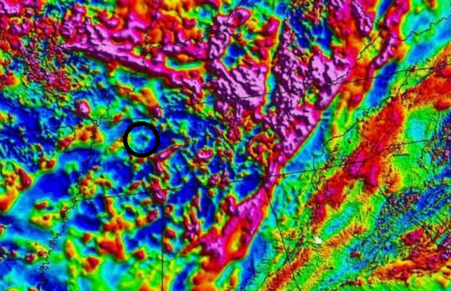
Cumberland County, KY crater as seen on USGS gravity map. July 14, 2023.


The Jacksboro/Rockwood crater impact crater wall exposure.
.jpg)
The Cumberland Gap Crater.
.jpg)
.jpg)
.jpg)
The Burmingham Central Crater which also busted a hole through the earth's crust, called a Crustus Confractus.
US Karst Map shown above with major circular anomalies.
.jpg)
Impact that made the Brassfield Chert >>>>>

The New Johnsonville DuPont waste injection well log. State of TN GM 30-NE. It shows the major events in the geologic column at Waverly area NW middle, TN along the TN river. The dotted lines are "unconformities." These wiping events are large meteor impacts in the area. The unconformities will stretch out laterally around the crater for many crater diameters.
Well's Creek Impact >>>>>
Frankewing, TN Impact >>>>>
Lewis/Perry County Impact >>>>>
Kentucky Basin Impact >>>>>
Middle TN Basin Impact >>>>>
Silurian Extinction >>>>>
End Cambrian Impact >>>>
While I am sure the "Unconfromities" are records of earth impact events; I cannot be sure about the specific impact. The closer the impact the more it does corelate. Also these events corelate to the changing of geologic era's. Shown below is the four big blasters north. It is a state of Illinois tectonic workshop map. You can see the north KY impact predates the others.


This is an exposed crater wall from the N central KY impact showing ash. This ash is from the Silurian Extinction Event. The top unconformity is the later smaller impact of North Central KY.
View of the Cherokee unconformity between the Brassfield and Drakes formations (eastern outcrop belt), south of Owingsville, Kentucky (Fig. 1), near I-64, just before the pinchout of the Belfast Member The Silurian of central Kentucky, U.S.A.: Stratigraphy, palaeoenvironments and palaeoecology
.jpg)
Lewisburg Glade Crater >>>>
Lewisburg Glade Crater - Thin soil over hard limestone is a crater indicator as is the circular nature of the topo form.


Various circle topo exposures. Many only partial arcs. The biggest impacts were early on and can be only partial arc features due to over hits or tectonic shifts. The Frankewing, TN Impact seems to have hit in a double crater wall overlap structure.

East TN and the complex MT orogeny crater forms. Which came first? Well some appear to be during. Fun huh?

Why I say the phenomena of crater size is different. Trinity test site, a few hundred feet (shown left side of screen). Well's creek a small dry land hit, 8 mile crater (shown right side of screen). And the Frankewing, TN Impact into a sea with 60 mile crater and sand push 60 miles southward.


End Cambrian Crater or Silurian Impact as shown on the drilling log above. Earthquake map. See how it is a crater shape. It is very old and under the large Silurian Impact. The earthquakes are caused by the busted Cambrian strata which is the foundation of the crustal support.

Crater walls as porous rubble often make cave circles around the crater.

Kevin James
·
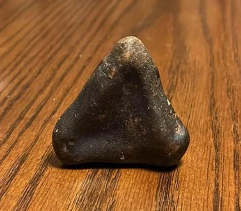
Not sure what I found . On the side
Of the mountain in Tennessee US-129 . Just for fun
So what does a fossil record actually record? Things that get buried. As I live in Tennessee and have collected fossils here for half a century I can tell you:
1. Shells, Tennessee has many fossil shells. They did not all die of old age. Most appear to have been suddenly buried. I have found tiny shell clams as small as 1/16 inch which certainly did not die of old age. Clam found to be over 500 years old - Phys.org
So since clams can live so much longer you would also expect to find a lot of them in fossil burial. Statistically over represented.
2. Assemblages, pile ups of burial rubble fossils. You often find masses of bits and broken pile ups of fossils. It looks like the picture above.
3. Shock altered specimens
4. Shells burned to ash in bentonite.
The so called fossil record does not record life in its habitat but rubbish heaps from some event that mashed them into a burial pile which facilitated fossilization.

Glades, they are likely crater signatures. Rock land surfaces with very little soil.
.jpg)

Impact Spheroids from the Silurian Impact found here at Lake Logan, TN. This is the oldest impact with exposure here. It was a Chondrite type of bolide. The impact spheres from the later impacts are iron.

The Great Unconformity Impact Structure shown with dotted line. It made a higher continent. Canada's crust was made thicker by several large impacts. The Silurian Impact is centered just above Memphis.
Slabs of North American Continent Are Layered Like Cake
By Live Science Staff August 31, 2010

Silurian Impact Sphere, Lake Logan, TN.

The wall of glass I call it. It is not that high in silica but is one giant hill of nano ash and iron from the Frankewing TN Impact as it was deposited on the Highland Rim in Western Wayne County along HW 64 road cut. It is all directional as identified by the fractal tree configurations from east to west.

Large high iron impact spheres found in Central KY by Greg Williams.
.jpg)
The Silurian Impact Extinction Event - It is still in a tectonic resolving process. The Smoky Mountains are the crater wall. This was a lateral impact coming from the NW. Large and fast, it broke the earth's crust all the way down to the Cambrian granite and below. An earlier crust breaking impact occurred at the TN/NC border. A later radioactive Devonian crust breaker occurred at the KY/IL border.

<< Big MO Crater
Low angle impact signature. Break lines will make an arc. The arc is a sonic boom expressed in bedrock which cannot carry that shock speed.
.jpg)
Earthquakes are tectonic sounding events that connect up the unresolved craters. The Louisiana Sinkhole and the Brushy Creek Crater are an unresolved tectonic complex. The Ozark Crater is it the skid mark of a lateral impact or another impact? Are the Ozarks the back crater wall?

Number 4 above is the Lewis/Perry County Crater. It blasted down to the Silurian. You can see on the DuPont well log above that there are three un conformal events on the tope strata at New Johnsonville. The top one is likely Well's Creek. The second is Frankewing, TN so the third is the Lewis/Perry County Impact.

Road cut at Clifton, TN. This is not a deep time banded iron but a specific instant made cherty iron and ash coloring deposit from the Lewis/Perry County Impact. It has no radioactivity therefore not from the Frankewing, TN Impact.
_JPG.jpg)
Close up of collected specimen. It shows a "Fiber Crystal" and a shock organized granular geometric crystal habit construction. It is not sedimentary it is a metamorphic. The grey color is from ash and the iron is form the impacting bolide.

The shadow of the massive Birmingham Alabama crater still remains. It is likely that it came in from the NE although subsequent impacts also can erase crater wall circles.

Real nice suevite from the Well's Creek Crater collected by Carol Hughes of Dickson, TN. Very rare with fossil in upper left corner.

Bell Witch Cave Adams, TN. Upper left corner of picture is fractal lateral shock flow strata. Impact made structure. Caves as karst pockets are often located in crater walls. More info below for your virtual travel experience.
.jpg)

My new area of research. I believe this to be a crater wall pushed up from a sea with impact center at Hollywood, AL. The sandstone contains the once liquid iron from the meteor bolide. Location is Cooper Top 1,800 ft. elevation, Franklin County, TN. The earthquake record is the crust still resolving this stress.


Impact sphere nodule found KY Lake at Birmingham Point by: Tim Fowler.

The two large radioactive impact mineral shadows of KY.

Central TN is radioactive from the Howell Impact. Stopped by the crater walls of the Middle TN Basin Buster to the east and west. Howell hit in the lower crater wall distorting it as has some other crater in the NE section. The Middle TN Basin Buster made the Highland Rims as crater walls. I have found it's radioactive signature all the way over to Franklin County, TN as it meets the Highland Rim there.

Bear Hollow Mt. WMA Frankline County, TN. Radioactive splatter from Howell Impact.

Hamblin County, TN Imapct. Scale changing and Turing Cavitation - This is a shock wall or floor. The red is from the large earth hitting bolide iron in a pulverized nano state. This crater bottom strata is pointing toward the center of the impact blast which is coming from the lower right. Jason Bowman picture. This is the edge of the Douglas Lake Impact.
.jpg)
Johnson City and Piney Flats craters show up as karst shadows which are lose crater wall structures that make caves. Also shown is the Jacksboro to Rockwood crater karst shadow.

This is a type of impactite from the Jacksboro to Rockwood Crater. It is sand from the ocean that was there and iron from the bolide itself. They make those patterns as a harmonic from the shock waves.
Lives in Knoxville, Tennessee
From Niota, Tennessee

The Lewis/Perry County Impact made the phosphate deposits found there.

Different types of phosphate from impact. While phosphate occurs as a bio product Middle TN was an ocean and the big older phosphate is from the Middle TN Basin Buster which has been later blasted with smaller impacts which both excavate it and rearrange it.

Phosphate another mineral shadow of impact. The conversion of mass and motion into instant energy produces great heat which burns up the surrounds producing clays, and ash salts. This residual is valuable and mined in the veins which are typically shot into the crater wall by the explosion force dynamic for heavy minerals, but ash can populate the entire crater depending on the impact type. As a forensic progression you have other events that complicate the original structure which also tells what has happened.

Big earth impact burns occurred in these countries. Strangely Canado has been omitted.

Cave Circles show up as voids in crater walls but are a complex system of many earth events. Some like Sullivan County are still clear circles but the topography is more complex. Others are overlapping crater and big slider types that only present one crater side as the earth recoiled and absorbed a low angle large impact. The Howell impact hit in the lower crater wll of the Middle TN Basin Buster and rearranged the crater. I also suspect the Sullivan County Crater is a larger earth impact with multiple rings.


Hamblin County Crater, directional resonance impactite. It has separated some of the mineral content into a central circle harmonic and an off center radiating harmonic banding outward as it dissipates the energy. Dec. 12, 2022
Found this in East Tennessee this morning. Please tell me this isn’t a natural water mark in Chert, lol
Wells Creek Impactite - This is a triangle wave imprint with harmonic ridge. Black iron oxide coating. Erwin, TN area.
Oil Shale is a sweeping of the organic material and compressing it with the impact shock from the type of impact explosion. This is dependent upon the organic layout present and includes subsequent events. The North KY Impact is a slider low angle impact from the north it appears. The middle TN terrain was under a sea from a basin causing impact and rose to the east where you find plant fossils. This was blast disturbed at the end of the Devonian by the Howell Impact making the Chattanooga Shale. While some Chattanooga Shale does have carbon left like charcoal some is burnt out. The Howell Impact Chattanooga Shale ends at the top of Middle, TN.

Wells Creek TN Crater - Notice how much it looks like a typical mountain structure attributed to plate tectonics. Also note the many strata that are excavated.
1. Geology on a Digital elevation model. View from south to north. Geology of central uplift is: Orange peak, yellow and dark pink areas at center are Lower to middle Ordovician Limestone. This material was thrust upwards a distance as much as 800m+/-. Light Pink through to orange are Silurian, Devonian and Mississippian strata. Middle Ordovician Strata and above are flanking a ring structure (seen as a topographinc high). Generated by Graham Nickerson at Interactive Visualisation Systems, Fredericton, New Brunswick
While tectonic theory was an improvement on previous theory it falls way short of accounting for the many earth impacts and the fact that the earth is an impact accretion body.


This is a very nice find. It is an impact form from the Wells Creek Crater. It is a simi plastic spalling splashform impact sphere type. It is iron and silica. The iron is from the impacting bolide but often the silica is from sand as Middle, TN was likely a shallow ocean at the time. It has a rare feature called a fiber crystal red (Capelli Rossi). Fiber crystals are shredded mater that land on still hot plasma mater and fuse on the surface.
strange find I.D., geology, archaeology, paleontology, Native Artifacts
Sean Brooks · 9h ·
Any idea as to what this thing could be. It's heavier than it looks
Septarian mosaic nodule. From the Rockwood to Jacksboro impact crater. Specimen collected by: Carl Mize


Subduction crater made the Southern Appalachians. Is it one crater or two. The Gulf crater is later and pushes up a distortion wave into the low areas. The earthquake signatures identify two big old impacts which gets distorted with the next big impact. Notice how the New Madrid fault crumble is the overlap of two big crater edges. The New Madrid disturbance is considered to be in the Cambrian Strata.
Same thing out west a big subduction crater pushing up the Rocky Mountains and then the 4 state corner impact bust that up.

People don't remember these days but there was a very big earthquake 1755 Cape Ann, Mass. at over 6 on the Richter scale. This is the big Chesapeake Bay Impact rubble still resolving itself. A relatively recent impact. You can see the big Gulf Imapct is more settled. Same with Florida. Then you have the hard hitting smaller impact at TX, AK, VA, SC, PA, KY, MO.
The really big impacts of TN are still resolving the earth crustal stress although much older.

This is the edge of the Big MO crater.
Type 3 big exploding crater.
Type 3 big exploding crater.
< Fading edge of the big Type 2 subduction crater forming the Appalachian Southern section.
Small Type 3 crater >>
Small Type 3 crater >>
Small Type 3 crater >>
Small Type 3 crater >>
Small Type 3 double craters >>


Lee Isham
Shock made fossil Limpet octagon.
Dancy Raquel Peña Binkley · Sept. 14, 2022
I found this in my back yard 40 years ago. I grew up in East Nashville close to Trinity Lane and Jones Ave. I know it's man made but what could it be!


Type 2 impactite with resonance circle harmonic, fractal dispersion energy forms, and an energy shift to triangle wave, a type of shatter cone. The iron is from the impacting meteor/bolide therefore a type 2 impactite. Shock is a wave energy and causes a resonance which imprints these forms. The forms will shift as a quanta energy break. I think this is an edge effect specimen from the central/north KY big crater. The matrix is shock metamorphic, once sedimentary limestone now metamorphic. Arrow points toward the circle harmonic edge which breaks into fractals and triangle cone. Lower arrow points to the "ghost stage" of rejection patterns having formed circles a high energy type just before blending into a total mixed state.
Chad Montgomery · Oct. 20, 2022 ·
I found this in southern ky

Douglas Lake Impact Crater Impact nodule with high heat mosaic shrinkage. An excellent find. These bits and pieces are thrown out as ejecta in a plasma condition then cool, some crack and some shrink as a mosaic condition. Hope you don't mind but I need to add and share your post as it represents an illustration teaching example.
Oct. 22, 2022
Pigeon River, TN. Any ideas?

Fentress County, TN Impact iron splatter as seen at Pickett State Park. This detail is shaping the arc form you sometimes see as a resonate energy effect although most detail is not. This impact splatter is from the bolide itself. Usually observed as an insert in sandstone as an edge effect. David Liles photographer Feb. 12, 2023.

Impactites from the Rockwood to Jacksboro Crater. The spheres contain ash. They were so hot the cores burned up. The Impact Geometric is the only free standing one I have ever seen! They usually land on something and weld to it. Very rare! Oneida, TN Scott County.
May 17, 2023.
Aaron Morrow · ·
Not sure what this is or used to be. Found in East Tn where some dirt was recently removed. It was in with some other rock, a few were hollow inside but only contained rock debris. Crumbles like slate rock. Looks like slate but I'm no expert so please help with identification.
Edit: it is NOT magnetic. None of them are.
Edit 2: video and pics added of the other rocks found with it that I opened.

Mosaic heat Septarian making a geometric, also very uncommon.

The Basin Buster Impact which made the Highland Rims as crater walls. The Lewis/Perry county crater left side. The oblique Howell, TN Impact Structure, bottom left.

The major craters of TN. Type 2 subduction crater formed this section of the Appalachian Mountain chain. The Middle, TN Basin Buster. The Howell, TN Impact Structure, The Lewis/Perry County Crater, The Jacksboro to Rockwood Crater, and the Douglas Lake Crater. The Middle, TN Basin Buster appears to be the oldest, with the large subduction impact distorting its wall. Finally the Murfreesboro small crater which is bigger than the Wells Creek Crater. Sadly the "official" craters are too tiny to see at this scale. If you pull the geology maps of Murfreesboro and the next quad south Fosterville you will see only Ordovician strata in the center of this crater and some Chattanooga Shale and Ft. Payne chert dusting along the south crater rim. This dusting is from the Howell Impact. The Murfreesboro crater is the literal example of the famous saying about building more nuclear bombs in the cold war "Of the United States policy Churchill remarked, "If you go on with this nuclear arms race, all you are going to do is make the rubble bounce."

The Murfreesboro, TN Impact Crater. Part 1. Topo mapping craters. Not my first choice, is probably why after five years of impact phenomena I am just now working on this crater. I am a big fan of geology anomaly maps, but this crater presents well on Topography. Take a good look at this too well-formed circular feature. Circles are the least likely tectonic feature by the way. Compression stress between planes will never wrinkle like that. The mechanical process of circles requires a bending die or shoe in the shape of a circle. May 25, 2023.

The Murfreesboro, TN Impact Crater Part 2: How old is this crater? The TN Dept of Geology Quad Maps are all Ordovician except for a dusting of Chatanooga Shale and Fort Payne Chert on the lower crater wall in the Fosterville Quad. The Chatanooga Shale and Fort Payne Chert are impact products of the Howell, TN Impact Structure so this crater pre-dates the end of the Devonian. The attached well log was provided by Ron Clendening of the TN Dept of Geology. It is the well log made by DuPont when closing the New Johnsonville plant to make a deep injection waste disposal. The unconformities are impact events. Speaking of unconformities how do you have such a large area of exposed Ordovician strata? The Middle, TN shallow sea must have ended at or around the end of the Silurian and early Devonian periods. May 25, 2023.
The Murfreesboro, TN Impact Crater - Making the rubble bounce.
_jfif.jpg)
The Murfreesboro, TN Impact Crater Part 3: The Karst Shadow. Impact craters often make a crater ruble wall with voids hence caves and sinkholes. (see https://www.researchgate.net/publication/229632679_Yucatan_karst_features_and_the_size_of_Chicxulub_crater ) Attached is the TN cave and sinkhole mapping. It corresponds with the Murfreesboro Crater. My favorite cave John C Overall is located in the karst shadow of this impact. And of course, Snail Shell Cave is a product of this impact. May 25, 2023.

The Murfreesboro, TN Impact Crater Part 4: Blast Crevassing. The Slaughter Pen at Stones River Battlefield is an impact made crevassed surface cut laterally by the tremendous force of explosion. The explosion contains grit particles atomized in the early stages of the impact progression. May 26, 2023.

The Murfreesboro Crater Part 5: Topo Overview. The crater walls are 150 to 350 off the crater floor. Highest elevation in Rutherford county is crater wall at 1,365 on southeastern border with Cannon County. The crater floor is glades. Over 140 caves the most in the central basin. May 26, 2023.

Murfreesboro, TN Impact Crater Part 6: Earthquake Ring. For the same reason impact craters make a karst shadow ring and caves i.e., impact rubble. The earth crust is broken beneath craters and resolves this impact stress periodically with a quake. If you connect the large dots on the USGS earthquake hazard map below Nashville, you get a ring around Murfreesboro. May 27, 2023.

5285 Eagleville Pike, Eagleville, TN 37060 Part 7 Murfreesboro, TN Impact Crater. Impact Mega Clast. These may be on the surface or just beneath. This farm has been excavating them to run a water line into the property. You can find these inside or outside the crater wall. The reason for that is these are earth strata shock melted and ejected great distances as part of the ejecta strewn field. Crater walls are a nominal end stage surface event and are a poor representation of the total energy. The iron splatter on the surface of these mega clast is imparted from the impacting bolide itself as both the earth surface where hit and the bolide become liquid from the shock energy. The surface white (shock white) may or may not be a weathering effect as the buried specimens seem to have the same surface. May 29, 2023.

Murfreesboro, TN Impact Crater Part 8: Impact Stippling Splatterform. Particle debris imprinting surface of impactite. What a great example. The matrix was still a liquid as these impalements made circles and ridges. The matrix itself is in a common particle constellationing rejection pattern surface as it cooled. Pull Tight Hill Rd. Highest point in Williamson County, TN on the west crater wall. May 28, 2023.


Murfreesboro, TN Impact Crater Part 9: SE Inside Crater Wall, Shock Broccoli, fiber crystals, and Impact Mega Clast. 4492 Murray Kittrell Rd, Readyville, TN 37149. Shock Broccoli is a rare impact phenomenon only found close in, to the impact centers. It is a impact heat expansion, fast form. It likely arrives as a secondary splatterform but is very well bonded to the matrix. Fiber crystals are also rare and are the impact version of Pele Hair, a shredded matter filament (circled in pictures). Impact Mega Clast shown in unmoved, in situ, where it landed state.

Murfreesboro, TN Impact Crater Part 10: SE Inside Crater Wall, Glassing and Shatter Coning Pure Triangle Harmonic Wave. 4492 Murray Kittrell Rd, Readyville, TN 37149.
Shatter cones as found at Wells Creek are a low power harmonic wave imprint. Higher GPa (Giga Pascal) shatter cones will not be striated. The power is also indicated by the steepness of angle. The overlapping triangle wave is a multiple harmonic wave imprint. Waves are energy in motion, but an explosion this large requires some distance for waves to overtake and organize. Note how the waves all point the same direction. While it is believed that shatter cones will point the direction of the impact, this is not true. There are many explosion shock waves in an impact this large as the bolide is not uniform nor is the impacted surface, and waves can also reflect. Glassing is a shock dolomite grain and can even produce melt beads. This specimen is in a proto state of melt beading.

Murfreesboro, TN Impact Crater, Part 11: SE Blast Surface Mosaic Cracking, at Unionville, TN. 3640 HW 31A. Melt surfaces. June 5, 2023.


Murfreesboro, TN Impact Crater, Part 12. Impact Geode Cannon County, TN from the Murfreesboro, TN Crater. Pseudo Cubic Keokuk Type Geode, which gets its name from location in Iowa but also found across the river in Illinois. These are also found in Lawrence, County, TN from the Howell, TN Impact Structure. This is a fast formed shock made orogeny. With 100 mm Macro Lense you can see the cone in cone "shatter cone" in quartz surrounding the geode square crystal void. The microscopic structure of the quartz shatter cones is highly likely to be Planar Deformation Features (PDF). June 5, 2023.

Murfreesboro, TN Impact Crater, Part 13: Strata round impactite voids and high energy fractal matrix. The matrix also shows the impact common particles organized in high energy geometric configuration circles. Readyville, TN 70S. Highway road cut. June 7, 2023.


Impact sphere barrel, from the Murfreesboro, TN Impact Crater. In the attached magnification 1. The fractal particle pattern a signature of energy orogeny. 2. & 3. Later small sphere impalements, 3 an iron sphere impalement from the impacting meteor/bolide. Sept. 7, 2023.
Rock Seeker - Rockhound and Rock Collecting Group
Hunter Megela · ·
Found this in a creek bed in Woodbury, TN recently just thought it had a strange interesting shape to it and decided to keep it yet it kinda reminds me of wood almost with the inside texture of it though!
Murfreesboro, TN Impact Crater, Part 14: Strata fractal iron inclusion. This is not common for iron inclusions. A fractal structure is an energy signature. Readyville, TN 70S. Highway road cut. See this article: https://www.researchgate.net/.../300561563_The_Formation...
June 8, 2023.

Murfreesboro, TN Impact Crater, Part 15: Strata Heat Mosaic Separation. Left side marked 1 is a true crack. Right side toward Murfreesboro is a Heat Mosaic Separation from cooling and a directional energy signature to the left and down. Readyville, TN 70S. Highway road cut. June 9, 2023.

Sparta, TN Crater Part 1. Evidence of an impact event is clearly seen in the Blue Springs Cave with coning features in stress patterns in the walls. You can read lots of technical articles about the Kart features surrounding the Chicxulub Crater. But let's start with Topography. A double ring crater with high crater walls. A fifty mile diameter crater like the Murfreesboro Crater. You can see the coning stress patterns at the bottom of this page: https://www.hillbillyu.com/shatter-cones-impact-crater
June 13, 2023.

Sparta, TN Crater, Part 2: Bio Impactite - Just like Earth craters impactites can be covered with plants actually growing on them. I think it makes them more interesting. This is a shock made chert partially melt fused and partially not. You can see the shock conglomerate sections, the iron section exposed, as well as the variety of lichens, and moss living on the surface. Shock conglomerates with the meteor iron binder are the principle impactite of the Lewis/Perry County Crater. Bald Knob Rd. Van Buren County, TN. June 14, 2023.

Sparta, TN Crater Part 3 - Blast Clast, split upon landing with debris from event landing on top just as the day it happened. Sparta, TN Crater at Bald Knob Mt. This is why I prefer to do crater research in rural areas. Van Buren, County, TN is the second least populated county in the state. June 14, 2023.


Sparta, TN Crater, Part 4 - Breccia coning in highly compressed calcium bentonite impact ash. HW 111S to Spencer just south of HW 1 junction at crater wall. Road cut with quarry beside road. Picture one is the rock along the highway. Picture two is the quarry. Picture three is a high shock mini coning within coning. Picture four is the breccia coning which is new and the only example of this phenomenon I have seen. Since this specimen was excavated from the quarry strata is it from this impact or a previous one? Impact is such a large amount of energy I assume it to be from the Sparta Impact. Crater walls are an assemblage of shock compressed debris from the impact that makes them. Caves in crater walls are a better representation of the uncompressed debris of impact. Blast crevasses are seen along crater walls and hent of the cave openings of some caves. Additionally you will note the squiggles and fiber crystals i.e. shredded matter in a viscous state. Impact has burned the limestone strata into calcium bentonite ash, broken the strata into a viscous blast piece state, formed shatter coning and highly compressed this all as one continuous function. June 15, 2023.


Sparta, TN Crater, Part 5: Blast Crevasse Directionality. Just like the Murfreesboro, TN crater the roadside blast effect pits have an angle of directionality with exact tilt to the center of impact! Crater edge at HW 111S toward Spencer just south of HW 1 junction at inner crater wall. Second picture is the secondary tilt in the blast column. A mixed tilt stack from the column as a simi pliant body. Notice this blast column is bigger than the Murfreesboro similar location blast crevasses. Iron stain is from the meteor/bolide as a vapor either in the blast wave or falling as an after coating. The iron content of this impactor may have been higher than the Murfreesboro impactor. The Howell bolide was radioactive and is responsible for the Middle, TN radon. There is a skip to East, TN and the radon picks up again therefore one of the East, TN impactors was also radioactive. June 16, 2023.

Spart, TN Impact Crater Part 6: Dendrites. Dendrites are an energy form just like lightning which they resemble. They are a charged deposition made by the turbulent blast particles with nano charged conductive metals (iron and manganese.) Most familiar as manganese, you will see this effect in iron as well in and around the impact area. This deposition will make a cleavage plane in the impact strata and can often be found in quarries in the impact area. This specimen was found in a quarry along the South Putnam County, TN HW 84 Dug Hill area. The specimen matrix is a shock compressed impact ash, calcium bentonite. This location is the NE crater wall complex. Note the deposition will separate the iron from the manganese. Manganese is a conductor, and its root word is magnet. The splatter type of dendrite as shown is a type of ball lightning where the branching charge is breaking up into a sputter. June 19, 2023.

Sparta, TN Impact Crater, Part 7: Banded Thin Plane Deposition/Coating. While I have found this phenomena on impactite specimens here in the Howell Crater, the banding is new. Micro thin and so well applied it does not chip off separately. The matrix is impact compressed formerly limestone impact ash a calcium bentonite. HW 84 south Putnam County, TN quarry, Dug Hill area. These thin plane coatings will be the cleavage plane as they are a dissimilar bonding and separate orogeny event construction. The banding is a wave form harmonic present at high energy depositing. June 19, 2023.


Sparta, TN Crater, Part 8: Planar Deformation Features. Crater edge at HW 70S roadside quarry rock just past the Sparta HW junction going south to Spencer at inner SW crater wall. Banding quartz and carnelian with a rare beading edge which I am still investigating. Picture was taken with a 100mm macro lens with resolution down to 25 microns. Planar Deformation Features (PDF) are the cross-hatching crystal structure. This is a cross shock while forming, a record of the high energy resonate explosion orogeny. June 21, 2023.

Sparta, TN Crater, Part 9: Micro Oolitic Sphere Beading. Crater edge at HW 70S roadside quarry rock just past the Sparta HW junction going south to Spencer at inner SW crater wall. While I have encountered shock beading here at the Howell Impact Structure, this type is different. You can see that some of the beads encase tiny bits of the impact debris. The beads are not shock melted together and seem to be just compression attached. Is also a fuzzy edge, also uncommon and indicates a pseudo sphere state, still in a transition form to complete melt. This is commensurate with where it was found at the crater wall. Resolution is at 25 nanometers. This is a new phenomenon in contest with the geode type specimen. June 21, 2023.

Sparta, TN Impact Crater, Part 10: Caves and intermixed sandstone. Caves are common to impact craters and will often even make a ring around the crater as they are found in the crater walls. (See Chixulub Crater wall karst circle). Caves are the dominate feature of this impact crater. Why is that? First there was an inland sea stretching all the way down to Sand Mountain, Alabama making for a high volume of impact sandstone. Second the rubble volume is increased when you have a central uplift rubble as well. Third, contrary to the water dissolving limestone idea, you will find caves in sandstone and chert. What that has in common is an impact and rubble with spacings that allow for a connecting flow which can and often does have erosion pipe physics and quickly erodes sandstone. Erosion pipe physics is the second leading cause of earthen dam failures, a backwards erosion of water going under the dam and back through it to the lake to make a shorter path, as pressure is involved. In the picture taken at the cave on the Prater Place/Hemlock Falls Trail (Falls Creek Falls, State Park) you can see in the upper left, iron which is from the impacting meteor/bolide. The strata is an impact breccia chert compete with voids, like I said, rubble has voids. Inside the Blue Springs Cave you will find rooms full of sand. This was once sandstone removed by the water flow to a lower level (see back cover of the Blue Springs Cave book.) Additionally the map of Blue Springs Cave like most caves shows redundant passages, alot of them. This is the reach back pressure to erode a second less pressure path. Caves are usually thought of as gravity erosion paths but the complexity of their maps indicates pressure as a separate issue with up, down, and sideways all options for new paths. Anytime the flow is stopped or delayed the pressure increases. So the factors involved in cave density are: 1. Amount of voids made by the original impact. 2. Amount of weaker materials in the mix. 3. The amount of rain per annum. 4. How long it has been since the crater was formed. All of which were high for this crater.


Sparta, TN Impact Crater, Part 11, Impact Erratics. Both above and below this sandstone boulder are shelfs of other sandstone blocks, so why this lone boulder? If it slid down the hill why is there no evidence or other debris? If this was left from the inland sea, why would it be squared off and a lone standing boulder? Why does it have an iron surface?
An Impact Erratic is a single fall not with any group of other impact material. The above and below similar boulders (see last picture) have a grouping but are also squared off and in a jumble not indicative of a sedimentary process.
Located about 10 miles east of Spencer, TN. June 27, 2023.

Sparta, TN Impact Crater, Part 12: Gravity Map, Impact Angle. The average impact angle is 45 degrees. In this case from the NE. The big caves are all in the west to south areas as well. The central uplift material is not the major mass of this impact, just a rebounding latter effect after the major mass was stopped. While it is thought that 100% of the incoming meteor will explode you can see a mass in the NW quadrant of higher density so even if it all exploded it was not a uniform dispersal. Notice that a town like McMinnville shows up as a gravity feature due to all the buildings.

New possible craters, The Hardin County, and West Shiloh. June 27, 2023.

Bath Springs Quad. Crater Indicators: Sulfur Springs. Sulfur is common to meteorites and Earth impacts. Bath Springs is just below Sulfur Springs. The topo shows a "cave hollow." Caves are a common crater feature. The river runs through a circular feature. The quad goes all the way through the Quaternary to Ordovician. Impact is the surface excavator. This is another possible crater. June 29, 2023.

Crater Fingers - Fractal branching is a common energy figure we are most familiar seeing it as lightning. It is also common to craters. Fault shifts are another crater signature as a previous impact tectonic event is overlayed by another. The Howell, TN arc faults are from a lateral impact with an oval crater, very rare. The missing parts to crater circles are how we can infer sequence of geological activity. Craters identified topographically are recent. As the Universe is an explosion and explosions sort with big pieces more likely to interact first a big crater is likely to be older. Impacts into seas will have a flow back into the crater which breaks down the walls a common Earth crater form. Rivers often flow through craters and follow these contours as a vestigial feature. Earth Impacts make soils, mineral deposits, depressions, glades, swamps, and tectonic earth crust breaks. Even the smallest Earth Impact is not reproducable and the evidence is a forensic examination. June 30, 2023.


Covington, TN is NE of Memphis and part of the New Madrid fault complex. The USGS gravity map clearly shows a crater of 40 + miles diameter. There is a westward gravity density which could contain some of the exploded impacting bolide. Impact crust breaks (Crusta Confractus) which are still resolving as a tight under crater circle and are likely relatively recent geologically. There is no plate tectonic reason for this highly unstable New Madid isolate. This isolate is identified in the detailed earthquake epicenter map. As the Murfreesboro crater still has a ring of earthquakes around it we know craters this size are still resolving lower stress cracks and rubble. There are two velocities to these impacting bolides. The first is captured speed roughly 15 miles per second. These are objects captured in our solar system. Cosmic speed is objects coming in from outside the solar system and they can be 30 plus miles per second as the Howell Impact likely was. The Howell, TN Impact made "arc faults" which are shown on the state geological maps. There is also an arc fault deformation in the New Madrid NW crust cracks from the very large Big MO Missouri crater which would have been earlier and may have been traveling into the crust from the NW. That leaves only the north to south arc which I believe to be from a large Silurian Impact that made a shock floor strata across the state and coincides with a major extinction event.


Tennessee Craters as exemplars of impact velocity dynamics. The Murfreesboro Crater is an example of a captured speed impact (15 miles per second) into a hard surface (See figure 1 https://www.mdpi.com/2076-3417/10/4/1393 Order Article Reprints Open AccessArticle
Cratering for Impact of Hypervelocity Projectiles into Granite Targets within a Velocity Range of 1.91–3.99 km/s: Experiments and Analysis
1,*byXiaofeng Wang1,2,Jingbo Liu1,Biao Wu2,Defeng Kong2,Jiarong Huang2,Xiangyun Xu2 andXin Bao
1 Department of Civil Engineering, Tsinghua University, Beijing 100084, China
2 Institute of Defense Engineering, AMS, PLA, Beijing 100036, China
Author to whom correspondence should be addressed.
Appl. Sci. 2020, 10(4), 1393; https://doi.org/10.3390/app10041393
Received: 19 December 2019 / Revised: 9 February 2020 / Accepted: 15 February 2020 / Published: 19 February 2020
(This article belongs to the Section Earth Sciences and Geography)
The Covington, TN crater is also a hypervelocity impact but it's cratering is deep rather than wide and it is a suspect cosmic speed impact (30 + miles per second) (See figure 2 from Wiki https://en.wikipedia.org/wiki/Hypervelocity )
The earthquake record shows a wide low power ring around the Murfreesboro crater but a deep strong earthquake record below the Covington crater. This is due to the relative density of the bolides, the surface, and the velocities (See figures 3 Murfreesboro and 4 Covington.) Figure 5 shows the crater shape and explosion depth based on nuclear bomb detonations studies. This is the same concept as 2x velocity as the explosion will occur 2x deeper.
The conclusion is that for the reasons stated above the Covington crater has a deep disturbed Earth crust layer below it of rubble which is still resolving with powerful earthquakes. While the mechanics of impact explains this. The amount of time to resolve is also a factor but still would not address the earthquake shape signature. As the craters are of similar sizes and crater size and time are relational this factor is assumed to be of small significance.
Earthquake risk data for Covington, TN - https://www.homefacts.com/.../Tipton-County/Covington.html
https://www.homefacts.com/.../Murfreesboro.htmlEarthquake risk data for Murfreesboro, TN -


The Howell, TN Impact Structure is the only known "Fan Crater" with two uplifts. Uplifts are the rebounding of rubble. The rebounding of rubble is a Rubble mound (retarc) formed by the WhetstoneSulky explosion. When the material above the explosion is solid rock, then a mound may be formed by broken rock that has a greater volume. This type of mound has been called "retarc", "crater" spelled backwards. Picture 4 is the famous Rubble mound (retarc) formed by the Whetstone Sulky explosion by buried nuclear bomb testing. A Retarc is the "central uplift" phenomena some craters have and some don't it depends on how far the bolide penetrated before exploding.
The Howell, TN Impact Structure is big, recent (Mississippian) and likely a cosmic speed (30 + miles per second) impact by a dense high iron bolide. It is also radioactive. It is the most interesting known crater. In the case of the Howell Impact Structure this occurred twice. The first on the right side was from the initial explosion and the second was a reflected shock up angle. The crater excavated down into the Ordovician strata. The three fan shaped fault arcs are a record of this low angle impact but are not uncommon. Arc faults show up often in the earthquake record as you can see at the New Madrid Fault Complex (see picture 5). The difference is that the Howell Impact Structure is a recent surface explosion, and the earthquake arc faults are older and deeper. July 5, 2023.


The Shelbyville, TN Impact Crater - Picture 1 is the Topo map. While not an easy circle crater like some of the other topo craters, I have perused this area and it is a thin soil rock famous for walking horse pasture. This is quite similar to the Murfreesboro crater which is understandable considering they both smacked into the larger previous crater excavation. Picture 2 is the gravity anomaly map. Note the contrast. Picture 3 is the magnetic anomaly map showing a good circle contrast. Like a doctor I do not use the superficial surface exposure as my evaluation. Also like so many areas in TN you don't find a big town in the center of the crater. July 28, 2023.

Ten miles SE of Shelbyville. Crater floor plasma scaring. So, I hate to digress, but for your benefit let's take a moment to do comparative theory. The erosion theory would contend that these pits were chemically eroded. Why would they make these patterns? It begs that question. If more easily eroded material were placed in these patterns what would have caused that? Notice that we have a change of scale along the edges, how would you have a change in dissolving pattern in so close an area?
Crater floor plasma scaring theory. This would explain the forms and the pitting all in one action. The multi directional nature of the scaring is explosion chaos turbulence as this location would be nearing the crater edge.
Easy craters and the out-of-town expert official crater approval problem. This crater is a good example of not easy investigation. It does not make a topo crater like Well's Creek or the Barringer Crater both smaller craters. It is an excellent "magnetic crater." It is very similar to a bullet wound that you can only see what happened with an x-ray and MRI.
July 29, 2023.

The Shelbyville, TN Impact Crater - As you can see this landed in an existing crater ridge/wall. The explosion therefore occurred at a height above the western plain. Call it the same problem artillery shells have when hitting a tank with a screen surrounding it. Explosion at the screen does not penetrate the tank armor deeply but makes a surface scaring not a conventional crater. July 30, 2023.

More so than with a hit and bury then explode crater a hit to a high point of uneven surface will cause blast wave crater ripples. You can see them well in the west side of this crater but also in the SE section. When making surface damage you want to explode above the plain to be destroyed. This was first calculated by Johnny Von Neuman for the Atomic bomb drops with the world's only super computer
QuadrangleSinkholes
Talbott1284
Verona1124
This table shows the western edge of the Shelbyville crater quad at Verona to be second in the state for sinkhole which are an effect of impact craters. The impact crater will make a rubble with pockets that collapse over time causing sinkholes.

The Sequatchie Valley Undulation, a result of the pressure wave as shown in diagram above. As the type 2 subduction impact the Mountain builder continued below the crust these ridges are less pronounced. Aug. 7, 2023.

Impactite, meteor marbling, Allen County, KY crater. Type 2 impactite, a mix of the meteor material (iron) and the impacted surface. As this is a relatively small crater I posit that the fossils were in the strata already as happened at even a larger crater I have studied for five years the Howell, TN Impact Structure. While the impact was a likely Devonian event the fossils could be much older. This is one of the many problems with William Smith Fossil Dating System. The county is a rich mineral resource and confirms the thesis of new book: Impact Crater Tectonics: The Future of Resource Exploration Paperback – March 27, 2022. USGS gravity map attached. Only craters are likely to make a circular feature as you can prove easily with two sheets of paper tectonic folding will not make circles. The Mississippi Valley Type (MVT) thesis is also bogus as nobody has ever identified these sources of "spring releases." Nor is this slag, I study slag. I hope you don't mind if I add your specimen to my encyclopedia of KY/TN craters. Aug. 7, 2023.


The McNairy, TN Fossil Site.
The McNairy County/Hardin County topographic concentric implied impact orogeny. Fossils as a rapid burial preservation. You would logically find these at the edge of the impact event in and around the walls. Notice how white the specimens are, shock white. Aug. 15, 2023.
UTM College of Agriculture and Applied Sciences
·
The College welcomes Mr. Josh Ratliff, as a new full-time lecturer at The University of Tennessee at Martin Coon Creek Science Center through The University of Tennessee - Martin McNairy County Center/Selmer. Josh is a UT Martin Alumni in Geosciences, has a Masters in Paleontology from the South Dakota School of Mines and Technology, and has been an adjunct faculty member for the UTM Selmer Center. He and his family live on the Coon Creek Campus.


The Milledgeville, TN suspect small crater can be seen on the USGS magnetic map. Aug. 16, 2023.
This suspect crater was a bust. There is no exposures and whatever is causing this magnetic signature is not visible on the surface. Aug. 18, 2023.

Acceleration and impact spheres. Impact spheres are melt drops blasted from a large earth impact crater. In this case that would likely be the Middle, TN Basin Buster which makes the Highland Rims of central, TN. Like running with a bubble wand the bubbles will elongate and make the teardrop aerodynamic shape. Your specimen is very rare in that it also received another impact sphere while in flight which is also slightly elongated. Aug. 16, 2023.
Rockhounding For Beginners
Curious. I have no idea what this is.
I have a bigger one also but this one is more detailed.
Located in Middle Tennessee
.jpg)
Crater 1 >>>>
<<<<< Crater 2
<<<< Crater 3
The three biggie craters of Kentucky.

Gravity Map Chegg Products and Services with Crater Overlay. You can easily see why the TN River runs up through that many crater intersection. The Crater Gravity Framework. Oct. 23, 2023.

Impact Botryoidal - A fast form, bubbling as opposed to a free impact sphere this is a lower energy state. Iron and sulfur are often found in meteorites. Can be found in impact spheres. Earth Impact big and small - You need a crater of around 25 miles diameter or greater for this. Topo crater or under crater as shown on anomaly maps? I see both at this location (Bardstown) and the later craters excavate the under craters. So let's take a look at the surface, see attached. Dec. 29, 2023.
These are pieces of marcasite, pyrite, or a similar sulfide mineral. There is a prominent horizon of this material in the lower part of the Laurel Dolomite in the Bardstown area. It breaks down in the presence of water, bacteria, and atmospheric gases, and forms an iron-stained band in outcrops.
Small pieces like this are common in gravel from the Haydon Materials quarry in Bardstown. They were also common in the old quarry on Highway 245 that was operated by various companies.
(I presume you found these in the Bardstown area, given your location.)
Jammie Coulter
What are these rocks

Here is an electrical conductivity map showing the under structure. Along with gravity and magnetic maps you can often see the composite impact layering. Dec. 29, 2023.
Article
Full-text available
-
Jul 2015

The same big under crater is shown on the geology anomaly maps. Dec. 29, 2023.

Looks like it hit from the NE.

Meteorites and Impactites - This impact sphere has iron, nickel, and sulfur common to meteorites. It is just a reflection of those being part of a multi mile diameter impact bolide that made the Howell, TN Impact Structure. Found at Lake Logan, TN. Dec. 29, 2023.

High heat mosaic from Tellico Crater, TN. Jan. 15, 2024.
JJ Hiker
Found along the Tellico River in TN, interesting pattern, about 8-9” long. At first glance it looked like the footprint of a Bigfoot


The Well's Creek Crater, impact from the east like at Howell, TN. See how the west side is more material.
Topo Coning - While known for its shatter cones look how the impact directional side is making these macro coning forms and not the east side from which the impacting bolide/meteor came. Shatter coning is a resonance made form with the majority of the resonance occurring on the receiving west side. Granted the overall topography has them as well but Middle, TN is a system of over lapping craters.
Jan. 18, 2024.


Round Impactite Spheroid/Proto Geode - Is there a typical impact concretion? Tektites and iron concretions are better known. The physics is non specific. Any materials involved in a large earth impact can be thrown out as a melt drop. The inner expansion can make geodes like shock agates are made, only geodes are without high energy resonance. This is from an old impact that made the Highland Rims of Middle TN as crater walls. Feb. 10, 2024.
Neon Burn · ·
Found this in northern middle Tennessee. Had a fracture in it so I opened it up, what is it?


Impact made concretion, chert to flint proto agate. What makes the lines? Resonate attenuation banding separation as the iron content is more dense and resonates differently than the loser chert matrix. Also this high energy formation fluidizes matter so this was more like stirring the color in a paint bucket. The core concentric lines are typical of a shock agate with the high energy cooking it from the inside out. Surface lines in a somewhat serpentine pattern are in a lose unmixed swirl. While the lowland Barrens is a suspect crater or the old bottom of the large crater that made the Middle. TN basin with the Highland Rims as walls, Tullahoma is adjacent to several more recent impacts. The Howell, TN Impact Structure may be the latest 300 mya. It has debris blasted into Franklin County, TN and even Jackson County, AL. In the attached map the Howell Structure is shown as the oval west of Tullahoma. BTW the other comments are correct this is a concretion nodule and while the sedimentary slow mechanism is plausible the matrix is a lose porous material and squiggly lines would not be a typical slow form as sediment compaction would tend to be two dimensional. I spent the past five years studying this area. You can read about it by searching "Hillbilly Universe." Feb. 20, 2024.
Hope Goins · ·
What makes the lines on the rock like these? Found in Tullahoma, Tennessee.


East TN Strontium Crater March 7, 2024. - USGS Map & USGS Magnetic Map.
Scientific Investigations Report 2017-5118
>> Pubs Warehouse > SIR 2017-5118
Geochemical and Mineralogical Maps, with Interpretation, for Soils of the Conterminous United States
By David B. Smith, Federico Solano, Laurel G. Woodruff, William F. Cannon, and Karl. J. Ellefsen

Radioactive Minerals and Objects
Emma Kate Lowe · ·
Just finished caving for about 9 hours in a Tennessee cave near Sparta. I recently got a Geiger counter, and I brought it into its first cave. Background levels were up around 300-600 CPM throughout most of the whole cave, especially the deeper we went.
However, I started placing it on our gear and clothes after a particularly long crawl where we were covered in dust and all of our gear were over 1000 CPM. Should we be concerned and can we “wash” it off? Is this normal for caves in this area as well?
This corresponds to the Strontium Crater shown above and the Sparta Crater. An impact like the Sparta crate can spread the radioactive particles widely. March 11, 2024.

Round Impactite Spheroid with inclusion(s) and surface high heat cracking, silica with iron. While there are 3 big craters in your area Johnson county is part of one so that would be source. These spheres and variants are liquid drops made when a large meteor/bolide strikes earth. They are part of the explosion and therefore get impalements and inclusions. March 16, 2024.
AmynDebbie Hall · ·
Not sure what this stone is, found in Johnson county ky.


Bad Theory - Here we have the Kentucky University system teaching what is now old rejected theory as peat bogs are no longer regarded as the source of coal. Besides that there is no know volcanic source of this coal producing mechanism in KY. Also you notice the trace iron in the coal which is from the impacting bolide as there is no reason for the bog to have free iron imparting and volcanic iron does not look like that. Very similar to the Mississippi Valley Type reason for iron a crack in the earth's crust that can never be found. March 17, 2024.
What's in Coal? Kentucky Geological Survey, University of Kentucky (uky.edu)

A pair of cojoined impact spheres. Interesting finding two. March 20, 2024.
Jen Wicks
Found in a creek bed Cheatham Co. I have never seen anything like them
.jpg)
Impactite tube - Like atomic bombs plasma bubbles are formed in large Earth impacts. Just a lower Middle, TN Impact Structure like the Howell, TN Impact Structure is around a 60 million megaton blast. Your specimen tube is sagging because it was formed so hot. It has fossils because it was part of an inland sea. You can see this crater on the Chegg Products & Services Geology Anomaly Map (attached). It appears to be a double hit crater. March 26, 2024.
Rockhounding For Beginners
Matt Cronenberg · ·
Got an interesting one for you all. This rock/fossil/lava tube or whatever it is was found at big Hill Pond State Park in Tennessee a few years ago. I have shown multiple people in person as well as sent photos to try and figure out what it is. There are imprints of seashells on the exterior of it, which makes it even stranger. Multiple people have said it is a mini lava tube that has pushed up against seashells as it was forming. I have researched the area and there is no history of volcanic activity that I have found. Anyone have any ideas of what it might be? At first I thought it was a bone that had petrified, but then started noticing all the seashell imprints on the exterior.


Impact sand and iron exposure. Pogue Creek Canyon. March 27, 2024. Crater shown below on Chegg Products & Services Geology Anomaly Map. This crater also encompasses Pickett State Park.

Like Karst rings, earthquake can make a shadow ring around a crater for the same reason as impact rubble makes voids. Due to either recency or strength some crater rings are still shifting. March 30, 2024.


While a shadow theory like Raft/Plate tectonics contains folding physics, these folds would be smooth and not on the surface. The more important boulder shown in this picture at the top is not folded. It has iron. Tubular iron composite smooth and limonite. in a vein. The macro earth physics of Raft/Plate tectonics is a poor explanation for two minerals of any kind in a small area as it is a macro process, and ores would differentiate by refining density on a macro scale. The Mississippi Valley Type (MVT) theory which is just a plagiarized restatement of the 19th century "Spring release" theory has never produced a source. As you can see on the attached USGS magnetic map while there is a large band along the eastern US mountains it is not uniform but is a mix of positive and negative circular forms as an example of impacts into a previous structure, like a large earlier Earth impact subduction from the west and then joins the Chesapeake Bay subduction from the east. As you see on the Moon and other planets large early craters are filled with later smaller craters. There is no Raft/Plate tectonics claimed for any other planets which in itself is a theory buster. It is impossible to make circular forms with Raft/Plate tectonics which you can easily prove with aluminum foil at your kitchen table. April 2, 2024.
Mark Abolins
The true story of tectonics at MTSU.
On March 23, MTSU undergraduates measured folds along the shore of Chickamauga Lake in East Tennessee. The folds formed many millions of years ago during uplift of the Appalachian Mountains.


Dolomite - New research article. Basically, they added energy and made dolomite. You can also read the wiki article on TN dolomite. So, what is my point? The metamorphic rocks we find, are more related to energy than time. Time is a sub function of event anyway. Like this new discovery with dolomite, you can also make fast diamonds with high pressure and resonance vibration. The Shaddy dolomite is also loaded with lead and zinc. Why? They cite the preposterous Mississippi Valley Type (MVT) theory. As I have cited many times it is a notoriously unproven theory. Lead is also mined in Middle, TN and is found to be of two different sources. So not only has one MVT source never been found now you would need two. Impact on the other hand explains the high energy and source even apart from the need for long time with low energy. The forensic logic is overwhelmingly in favor of impact. So, what would an intermountain impact look like? See attached topo. Not one but two craters roughly 25 miles diameter each and a quarter million megatons of explosive energy. April 8, 2024.
https://en.wikipedia.org/wiki/Shady_Dolomite
https://www.sciencedaily.com/rel.../2023/11/231123165111.htm

1
2
3
4
5
6
7
8
9
10

The Chegg Products & Services geology anomaly map and TN. First it is showing the Lewis/Perry county crater quite well, as an anomaly negative and marked as 1 on map. The Huntsville, Al crater appears to be quite similar and marked as 2 on map. Davidson not Rutherford county has a similar crater marked as 3. The Murfreesboro crater is vague on this map. This is due to it being an impact of a rock smacking into rock which will not make a gravity or magnetic signature well. The Howell, TN Impact Structure is shown as a nice half crater, anomaly positive and marked as 4. This is likely due to the low angle of the impact coming in from the NE. An impact is shown in Franklin county, TN which crater walls into Jackson county, AL This is marked as 5 and looks like it came in from the NW. The Sparta crater is shown as an anomaly positive and marked as 6. The Coon Creek Fossil Site in McNairy county appears to be part of a tri crater complex which blasted out this exposure and/or petrified the fossils. This is marked as 7, 8, & 9. You can see the Well's Creek Crater marked as 10. It makes a bigger geology anomaly impression than it does as a topo crater.

Lateral impact splatterform spray. Note the fractal bifurcation, that is an energy signature like lightning. The boulder is shock dolomite. The crater is shown on attached map. April 12, 2023.
Margaret Caulder · ·
Rocky Fork, TN
Seams or Striations?


Notice how the mining district makes an arc. April 12, 2024.

You can read more about impact craters and their impact mineral splatter in this new book. (2022).

Oneida, TN Crater. This crater is the blast that made the arches of Big South Fork National Park. April 15, 2024.


Finding the lost big crater. There is a section running through Alabama and Tennessee that makes a valley ridge which is the vestige of the Lost Big Crater. It got lost by other craters. You can see what happened on the attached USGS Magnetic Anomaly Map. April 15, 2024.

The more complete story of what happened. The arrow shows the trench flow from the Sequatchie Valley through sand mt in Alabama on down to the gulf. This flow was changed by the later South Illinois large crater to its present flow pattern.

USGS Magnetic Map of TN. The lower circle is the McMinnville/Sparta Crater Complex. The upper crater circle is the one that contained the Strontium as shown above.


Walden Ridge appears to be a central uplift to this crater. This is an impact into the valley ridge terrain. April 18, 2024.

The Strontium crater is also the closest crater to this crustal instability. April 19, 2024.

Under crater or the Strontium crater? Follow the circle radius of the Alabama/Mississippi Black Belt Crater back to its locus and it is in the same approximate location as the Strontium Crater. April 19, 2024.

Monroe and Polk Counties Craters. Visibile topographically as they crashed into previous crater rim and distorted.it. April. 19, 2024.

The Clay County Crater. Often water flow will pass through craters. They are a natural sink. Dale Hollow Lake just east is also a likely crater. April 30, 2024.

Cannon County, Tennessee, 1938...
Mr. & Mrs. Sam Wilchers, Route #2, Woodbury, Tenn. and the geodes they have plowed upon their farm on the highway between Murfreesboro and McMinnville.
Source
Tennessee Department of Conservation

Blast effects Jamestown, TN, note the surface iron. This caused me to redraw the Jacksboro to Rockwood Crater and retype it. May 26, 2024.
CZmazing US
Circle Bar Arch in Pogue Creek Canyon State Natural Area, Tennessee

That makes Rugby the center and it no longer a Retarc but a low angle type two subduction crater. May 26, 2024.


The Murfreesboro, TN Impact Crater is a Scandium Crater. This hard Ordovician surface strata could hove no reason for Scandium except it came from space. May 31, 2024.

Impact plasma hole tunnel from the big Mammoth Impact. May 31, 2024.
Jaek Cooper
May 29 at 9:07 AM · Slade, KY ·
So this is a cool thing from Red River Gorge in KY! I don't know if these have specific names or not. If anyone has more info please tell me, but this is a pocket in the side of a sandstone cliff that acts like an echo chamber or something when you get inside. You can hear things that are farther away pretty clear. I'm pretty certain these aren't man-made especially because you can see what looks like honeycomb weathering inside them, so that would probably mean there are pockets of weaker rock inside the harder sandstone being weathered in such a way that just so happens to create this unique little dome! If ya ever find one climb on in and just listen!
#redrivergorge #nature #geology
See less


Pancake type of impact sphere from Well's Creek Impact. While not impact glass the physics of formation are the same. See attached chart. Micheal Lininger specimen Erin, TN.

The Uranium "skid marks" are present for this type 2 subduction crater. While not exactly an oval it must have been low angle. Most impacts that make a crater make a round crater. This is because explosions expand in all directions equally. But when an incoming meteorite strikes the ground at a shallow angle — less than 15° above the local horizon — the resulting crater is no longer circular. Low-angle impacts produce craters with an oval outline. Here you can also see it came in from the west. June 19, 2024.

Impact sphere variant, limestone, stretch void. These are made like tektites but out of the impacted earth strata. Stretching ovals and oblates are from the high velocity while the specimen was in a plasma state. It is like stretching playdoh too thin. This meteor/bolide contained Scandium and can be seen on the USGS Scandium map. See attached. June 20, 2024.
Patsy C. Young · ·
I've never posted on here but this was given to
me tonight it was found in Eastern KY around Yatesville Lake area Lawrence Co KY and I'd like to know if anyone on here can tell something about it...


Bowl Splashform Type. June 20, 2024.


The impact crater minerals DuPont/Chemores, & Hyperion are working. Picture 1 shows the craters magnetic outline as provided by the USGS magnetic anomaly map. Picture 2 shows the same crater with the USGS zircon map. Picture 3 shows Humphres County, TN which as you can see is east of the crater. Picture 4 shows Hyperion's ever expanding mining claim. The Tennessee river erosion has provided the exposure for mining less deep, but the major deposit is west but deeper.
May 24, 2021.
Hyperion Grows Land Position at the Titan Project By 55%
-
Hyperion has increased its land position at the Titan Project by 2,114 acres to 5,964 acres, a 55% increase in landholding in a critical mineral rich province.
-
Drilling to date has confirmed consistent, thick, high-grade mineralization containing critical minerals including titanium, zircon, rare earths and silica over ~3.6km strike length.
-
The Company’s large and contiguous central land package has been the focus of the Phase 1 – 3 drilling campaigns, with an initial Mineral Resource Estimate for the project to be completed in the coming months.
-
The initial Mineral Resource Estimate will form the basis of the recently commenced Scoping Study for the Titan Project, due for delivery in Q3 2021.
-
A large portion of the new land position covers an area identified as highly prospective for critical minerals rich mineral sands through historical drilling by parties including DuPont and Altair International.
-
The Company has mobilized drill rigs to this area and will undertake drilling and commence metallurgical test work over the coming weeks.


Unknown room in cave. This is a coning structure with impact bricking types 1 and 2. Large rooms in caves are voids created in the impact rubble process. The narrow passages that connect them are geologic water flow processes. July 29, 2024.
Undergroundearth Caving ·
·
Lots of breakdown and BIG rooms today! #tennessee #caves

Mosaic progression from top to bottom increasing melt. Aug. 26, 2024. David Liles photograph, Big South Fork, Twin Arches trail.

Large plasma cavitation shown on right side. Surface melt flow to mosaic Septarian on left. Aug. 26, 2024. David Liles photograph, Big South Fork, Twin Arches trail.

Compression polygons, a type of column basalt structure and an impact geometric. Aug. 26, 2024.
David Liles photograph, Big South Fork, Twin Arches trail.

Shock circles, proto agate, Illuminati stones. Sept. 4, 2024.
Sheila Fisher · ·
Found in larue county Kentucky

New USGS Landslide Map. Like the Verdin Battlefield Craters it has a many crater distortion and crater walls most highlighted. I have circled some of my favorite craters of the SE. You will note that a very large impact underlies the SE. It is very old, but the wall effect is still quite visible in its lower half. The upper highland rim crater is somewhat big and retains its upper wall section, the Nashville Dome. And of course, the later Murfreesboro Crater is wall demarcated. You can see the unusual Howell, TN Impact Structure which is the most interesting crater on Earth. I recently moved to another crater the Cullman County Crater which was an impact into a very old shoreline. The north Alabama craters disrupted the shoreline flow into the ancient coastal gulf causing the shift of rivers back across TN to the Mississippi River. Geology Theory: The erosion theory of Middle, TN is the oldest theory with a slow sedimentation and erosion to explain. This goes all the way back to Hutton. While this theory does have application, you have to ask yourself why Rutherford County is eroded down to the Ordovician? If erosion were true a generalized bowl type of erosion would be the least likely as erosion forms fractal patterns. Next came Raft/Plate Tectonics. This theory cannot explain arcs or circles as raft plates pushed together will never make arcs or circles without the assumption of an unexplained circular raft piece. The latest theory is Impact Techtonics which agrees with the other planets and also resembles battlefield cratering. It also explains the surface ores much better than the also old Spring Release, Mississippi Valley Type Theory circa 1800's. This theory has never identified the supposed cracks in the Earth's Crust where these ores came from. Sept. 18, 2024.


Impact nodule cone with plasma hole burn on flat side. This type of cone is a reaction to the velocity as a plasma body in flight. While they can spall out a doughnut I am going with plasma hole burn on the hole. Sept. 30. 2024.
Samuel Capehart · ·
Odd found here in Overton Co Tn Today Any ideas??

USGS Magnetic map

Overton county, TN By David Benbennick


Impact nodule collision welded attachment. Kinda rare but stuff happens in an impact chaos event. Sept. 30, 2024.
Clarissa Heitman · ·
Any ideas on what this could possibly be?? I found it this summer in a creek bed in Overton County, Tennessee; along with some other extremely cool rocks!

Notice how the sheet ripple flow pattern from the water but above in the limestone is the true formation orogeny with ridge and crevasse upward. This is a void in the impact crater rubble where water erosion connects these voids that is the true cave process. Oct. 4, 2024.
Undergroundearth Caving
·
This was a fun cave in Fentress County, Tennessee! #Tennessee #caves


Impact made conglomerate nodule in impact ash shale matrix. Shell lithification is problematic with impact made specimens. The rock in the background is a high heat mosaic surface called shock broccoli. You can see the crater on the attached topo map. Oct. 8, 2024.
April Maupin · ·
Thank you for letting me join! Just found this over the weekend. If these are fossils I'd the first I've found. Found in northeast Tennessee at Cherokee lake area in shell. Can anyone tell what any of this is? And is there an easier way to get the shell out from around them? I've been using a needle and a small paint knife. Thanks!

Or does it look like this.

This is a better crater conforming to the topography. Oct. 8, 2024.

Meteor marbling with cobalt, iron and sulfur. Dec. 4, 2024.
Kentucky Geological Survey
Hump Day? Slump Day!
This rock core from #Kentucky's South-Central Mineral District shows a slump (a fold) in mudrocks with multiple layers (or laminae).
#KGS geologists Angela Torres-Zamora and Kurstin McKinney
Geologic photographer Natalie Fields

Boxwork theory. Iron is a poor precipitate. The process need oxidation which would be a red not brown as depicted here. This is similar to the brown iron ore of the Western, Highland Rim in TN. Specimen in top left is bubbling and even has bubble collapse as seen in slag. Where did the iron come from? The Mississippi Valley Type (MVT) is the recycling of a previous theory called "Spring Release" which conjectured a fissure in the earth's crust releasing iron. In 150 years of this theory no such fissure has ever been found in conjunction with this ore. So, what did cause this? Impact. In an impact shock chaos explosion multi directional high velocity splatter penetrates surrounds. That is a single physics that explains the origin of the iron and the presentation. The toxic iron precipitate from a sea theory is contrary to life which is usually found as fossils in the same area. That theory still requires an origin for the iron. Jan. 13, 2025.
John Tillson
You will see people photos of what is called boxwork mineralization. These are from the shore of ky lake.
Water passing though iron rich limestone precipitates the iron when it enters a zone where staying in solution is no longer possible. Many limestone formations have some sort of vertical cracking at unique angles. Water travels in the cracks and the iron deposits in unique patterns. These are an underlying chert layer. If the limestone would have not dissolved away These boxes would have continued to grow.
Yes, I can take a field trip to this location. Yes...they look like they are drizzled in limonite/hematite chocolate and yes, I was almost barefoot.

<< Bubbling
<< Bubbling Collapse

The Western Kentucky/Illinois Basin Crater. It likely continues a multiple impact basin. The typical problem with crater finding and mapping is thinking too small. Signs like you are finding would indicate a large crater. Mapping large craters is difficult and craters tend to start overlapping with size. The typical US state has around 2,000 based on Mars which has over 600,000 surface craters of a mile diameter or greater. Earth being twice its size would have 1.2 million. Larger craters are bigger deeper and have subsequent geology and small impacts. The north turn of the TN river is due to impact(s) in North Alabama, Black Warrior Basin, where it used to drain south, which is my new area of interest. Which brings us to your area the Illinois Basin. Both basins contain coal which could mean the impacts were carboniferous or basins are collectors of carbon. Your crater is radioactive like the HTIS. While still visible topographically the radon map does it better justice as crater walls are not the limit to the impact disturbance.

Topo Crater outline. Jan. 14, 2025.
Lee Isham so you admit that metamorphism actually exists.....care to explain how 5 a 50 million pound blob of molten iron could be put in direct contact with material and not have ANY metamorphism??
John Tillson that is a good question. What is metamorphic iron? First let's start with the energy. I needed to name this crater anyway. Owensboro is its center. It is a hundred miles in diameter, and .8 of Chicxulub or 80 million megatons. I needed that to consider what would happen to the iron in the meteor/bolide. It would be melted but it had been melted before when the meteor was made so twice melted but not isolated as one big lump when expelled. The meteor had iron and uranium but got mined out early like TN. " Western Kentucky
Some iron deposits were mined and smelted in furnaces in Caldwell, Trigg, and Lyon Counties in the early 1900's, and numerous furnaces were constructed to smelt the ore. The occurrences are minor, isolated bodies and are not economic.
Many of the iron furnaces are still standing, an interesting monument to a past mining era, and many have been preserved as historic sites." Ky geologic survey. The coal still makes me think this may be a late Devonian/early Carboniferous (Mississippian) impact. I would say the iron you are finding is in keeping with an impact explosion. The percentage of iron in meteorites is 5%. I might add that impact explosion pulverized and makes a plasma cloud like you see with the atomic explosions. This material will show up as red clay or as coatings on rock surfaces when it falls and bonds from the plasma cloud. The box work type is a liquid splatter phenomenon, veins are of that type. The impact ash you found was once limestone now calcium bentonite. This is a type 3 (surface exploding) crater. The average angle of impact is 45 degrees. This one appears to be from the NW. 11,900,000,000 short tons of iron would be the estimated distributed iron from this impact based on 5% iron and a ten-mile diameter meteor. The usuals ration for crater to impactor is 10 to 1. Isn't that interesting?
Weight of the earth in tons. 587 quintillion short tons. Since the earth is an accretion body made of meteors this is reasonable for the mass calculation of large impacting meteors.
10/25,000 is .0004 This is a ratio of a ten-mile sphere to earth.
.0004x587 = .2348 quintillion short tons
A quintillion is 10 raised to the 18th power.
238 quadrillion or 10 raised to the 15th power.
238,000,000,000,000 short tons.
The average meteorite has .05 percent iron.
238x.05=11.9
So the iron would be 11,900,000,000 short tons.

Tectonics. Take two foil sheets and ram them together. You will get tectonics. The edge will look like mountains. Where your hands were will be more rounded as it was a forming die/fixture. You will not get arcs and circles from two crashing linear sides. The West Kentucky circular ridge is much too round to be from any large earth plate push or pull. It is specifically round. It has to come from a round cause. Jan. 14, 2025.

If you measure the size of this crater by its karst signature or radon halo you can see it is more the size of Chicxulub at 120 miles diameter.

So wait, Owensboro to Franklin, KY is about 80 miles making this crater 150 to 160 miles diameter, bigger than Chicxulub. Jan. 15, 2025.

Plasma cavitation, Burmingham Ferry Campground. Jan. 15, 2025.
John Tillson photo.

You can see how the sand of NW Alabama and Western Kentucky match up on this map. Jan. 15, 2025.

Impact ash/clay which is nano pulverized particles and iron. One Horse Gap area, near Herod IL. This would be the other side of the crater in IL. Grant Twiss Outdoor Photography Jan. 9, 2025.

Plasma cavitation. This is even more west. So this crater protrudes across the bottom of Ilinois. Jan. 15, 2025.
Grant Twiss Outdoor Photography
Big Rocky Hollow Waterfall - Ferne Clyffe State Park

The Douglas Lake Crater is much larger than just Douglas Lake. You name craters by some recognizable landmark. I first became acquainted with this crater from pictures posted by David Lyles on his photography of hiking adventures. As you can see the above under represents this inter mountain impact. It broke up the ridge system to the SE . Jan. 24, 2025.

The Big Douglas Lake Impact Crater Complex. I first became acquainted with this crater from David Lyles photo essay of hiking the area and showing the impact rocks. It is a topo crater still showing the vestigial structure. Taking some time to really look at the topography you can see just how big it is. Let's just rough it in as 160 miles diameter. Now that is significantly bigger than the famous dinosaur killer Chicxulub in the Yucatan Peninsula at 120 miles diameter. As Chicxulub is rated at 100 million mega tons of energy the Douglas Lake impact would be 130 million megatons. These energies are far greater than any nuclear bomb ever exploded with the biggest being the Czar Bomba at 50 mega tons. These maps are available from: Relief Maps, 3D Maps, Topo Map Art, & More | Muir Way Jan. 24, 2025.

Ordovician/Cambrian event as shown on the above map. Jan. 24, 2025.

Shock circle pattern, the iron is from the impacting meteor/bolide. Jan. 28, 2025.
fossil information & identification
Found on Greeter Falls trail in Altamont, TN. What is this?


Tennessee is just like other planets if you use a geology anomaly map. About 2,000 surface craters of a mile diameter or greater per state. Jan. 28, 2025.

Earth Accretion Expansion Crack. Big accretions cause crust to rip apart. This rip extends down into Alabama. There are several very large impacts associated with this area. Feb. 2, 2025.
Dunlap Coke Ovens Coal mining museum and park ·
Map of the 70 miles long, 5 miles wide Sequatchie Valley to give a simplified idea to the unique geography and topography of this Southeast Tennessee region. Carson Camp Historic Photo Collection -Sequatchie Valley Historical Association

Impact scoria/cinder from the Mammoth Impact Crater (see attached map). It contains silica melt as well as nano iron from the impacting meteor/bolide therefore a type 2 impactite. While scoria is associated with volcanic events many of the same physics occur with impact. As your specimen is largely quartz perhaps once sand and evaporated it was around 3,000 degrees F a full 1,000 degrees above typical lava flow. In the attached map you will notice this large crater's excavation pattern with the younger strata on the edge and the oldest in the center. Impact is called the great excavator. The Mammoth Cave is on the crater wall where rubble leaves voids for water to connect. An impact like this is a type 3 surface explosion the stop and pop kind. Feb. 14, 2025.
Central KY any ideas? I'm thinking calcite or limestone formation has interesting growth patterns in areas though that make me question it being a fossil or remnant. Anonymous.

Anonymous participant
Author
Lee Isham problem is I found this further north of he middlesboro crater to far north to be from that or any known impact site

Source Crater as seen on the USGS Magnetic Anomaly Map.

The Paducah Crater. Sandstone with impact plasma cavitation. This is a much bigger crater than the excavation indicates. Feb. 14, 2025.
Heather Hicks
Elephant Head Arch
Edmonson County

Edmonson, County, KY


Found another smaller one on the Ky Geologic Survey Karst Map. Feb. 14, 2025.


First let's start with the oldest of geology theory, sedimentary deposit and erosion. That would make this mega clast the product of erosion over a great deal of time called deep time which was thought to be unlimited but now we know it is not. The tectonic theory is not good at producing holes as it is pressure based. Impact theory would say this is evaporation holes and or plasma burn holes. Karst/cave areas abound in KY but make two large crater circles. As you can see from the multitude of holes in your mega clast it would be easy for water dissolving erosion to connect them making a cave on a larger scale. Attached are the two major karst circles of KY with your county being at the intersection. March 12, 2025.
Guy Ferrill
Why does this have holes in it? This is no little rock it is a boulder on the back of my farm in Nelson County

Fossil and plasma holes an instant shock fossil. Conulariida are an extinct group of medusozoan cnidarians known from fossils spanning from the latest Ediacaran up until the Late Triassic.[1][2][3] They are almost exclusively known from their hard external structures (alternatively referred to as a theca, periderm or test), which were pyramidal in shape and made up of numerous lamellae. Feb. 25, 2025.

You can see the crater overlap progression from left to right getting younger. I rather think this fossil is much older. Feb. 25, 2025.

Some of the crates we can outline in this map. Is a lot going on here. March 9, 2025.
Copper Basin, TN/GA/NC
_jfif.jpg)


USGS magnetic anomaly map and the copper basin. March 13, 2025.

As a topo crater it is smaller which is not unusual. Also their are other small craters around but the larger magnetic crater may be the source of the copper.

Impact spheres, Copperhill, TN. David Liles photo. March 13, 2025.

Impact nodule. Notice how the flat surface has no wear. The green on the outside is olivine. It also has a smooth surface splatter and striations. The striations could be a fossil or could be a physics artifact. The uniformity suggest fossil. The bowling pin shape is often the connecting of impact spheres much the same way a lava lamp will connect bubbles. It is chert. March 17, 2025.
Terry Jeanette Lynch Carter
After the storms yesterday, we went on a walk through the woods on our property in Humphreys County Tennessee. My son found this close to a small creek. It is an interesting shape and very heavy; definitely a stone or rock of some type. Any one have any idea of what it might be? Looks like it is broken on one side.


Fault exposures on TN River but you can see a few fault exposures out wider. This could be a much larger crater or the outer faults of the Lewis/Perry County Crater. March 17, 2025.

Not an easy topo crater but seems to be centered around Bakersville. March 17, 2025.

A more detailed look shows a subduction push up crater with a smaller crater inside. As the New Johnsonville DuPont plant mined Titanium, aluminum and iron has also been mined in the area the meteor that hit here contained these elements. It likely came from outside our solar system. March 17, 2025.

Melt surface plating and striation lines. The melt surface which is almost gone is a representation of exposure to the high heat/pressure that took place during flight. The striation lines are actually a lower power effect like low pressure shatter cones which are striated. High energy shatter cones are melted thus lose striation which is shock wavelength imprint overlay as the cones themselves are sign wave imprints. March 22, 2025.

That is an impact sphere from the Mammoth Impact Crater. The amount of soil it is sunk in represents the sedimentary time since it fell there. It has trace iron making the colors. It hit in a period when sand was in Central KY. The Mammoth Impact Crater is the origin of the Mammoth Cave System as the edge rubble has voids which connect to form caves. Proximate location - As it is a sphere it has likely rolled down that hill at some time making age by surrounding difficult. You seldom see sandstone impact spheres, and large ones mean a large impact. The big three of KY shown on geology map attached. The SE crater going into TN is very old and just shows small traces of itself as it is under much more geologic events. March 22, 2025.
Rockhounds of Central Kentucky
So this thing is huge it's bigger than me and I'm 5'1 is this something or just a big sandrock? I'm in southeast KY in Whitley county.

Whitley County, KY

Impactite location - Generally speaking you would expect an impact sphere to fall inside the crater. But look how big this crater is. The fault center is south of its surface topology indicating it hit at an angle from the north or a more steep angle from the south, in any event the power of such an impact would have no trouble ejecting a sandstone impact sphere into Whitley County. All the impactites from the very old underlying crater would be deep and confused with the later geologic processes. March 22, 2025.

Have you ever noticed that when you explore a wild cave you go through small tunnels to connect to big rooms? The tunnels are actual limestone erosion the big rooms are crater rubble voids. The Mammoth Crater even has a central uplift karst area. As for the Middleboro Crater it is much too small to produce an impact sphere this large. March 23, 2025.
